Thursday 27 December 2018

Loughrigg

Monday 17th December 2018

Despite only recently recovering from a bit of ill-health I was eager to return to the Lake District for my annual Christmas holiday and I soon found there is nothing more recuperating than a good walk. The Lake District is the perfect place to revive your mind and body. After travelling up during the morning on the train as far as Windermere, I caught a bus to Rydal Church getting off at the very same place where I had started my first walk in the Lake District back in 2002. However, I immediately went a different route as on that previous occasion I had continued along the road from the bus stop and crossed the river on a footbridge to climb the northern slopes of Loughrigg above Rydal Water passing the large caves of the disused Loughrigg Quarries. This time I took a route over the high, rough precipices of Lanty Scar that Wainwright did not recommend saying it was dangerous in mist, but the latest version of Wainwright’s guides, the Walker’s Edition, does recommend this route saying it “is initially very attractive in rugged surroundings on an ingenuous path”.

After making my way back down the road to Pelter Bridge and the car park on the far side of the river, I found a slender path that climbs past recently planted trees. A lot of trees have been planted in the Lake District over the last couple of years to help replace the trees that were lost during the recent storms and to help stabilise the soil and prevent erosion. After crossing the fell wall I entered an area of bracken below impressive crags where a faint path led me up past the cliff-faces while dead bracken underfoot made route finding a little difficult. The views were very murky with Nab Scar, across the valley, half hidden amongst the low-lying clouds, but there was hardly a breath of wind, which is always welcome at the top of the fells. This lack of a cooling wind did mean that I soon had to start shedding the many layers that I had been wearing to keep warm while standing on cold railway platforms. Now that I was walking and climbing I didn’t need any warming layers besides my waterproof jacket as I tried to find my way through the complex terrain.

Wainwright’s Walker’s Edition indicates a path to the north of the line of outcrops, so I sought out the faint route through bracken and gradually the view across Loughrigg opened up with the summit now in sight on the far western edge of the fell. Towards the south my eye was drawn to a rather distinctive top that had a clearly defined peak and pyramid-shaped slopes, which must be the 246 metre height marked on Ordnance Survey maps. First, though, I wanted to visit the final top on the Lanty Scar ridge that I could see ahead of me had a cairn at the top, and from there the view across the whole length of the fell really opened up with a maze-like network of paths that leads all the way to the summit. A steep descent took me onto the clear path that runs from Loughrigg Quarries south and that was where I headed turning left towards the pyramid-shaped peak that I had seen earlier. On reaching a cairn that marks the highest point on the path I turned left to climb a short, pathless slope up to the top of the peak that I had seen earlier and was now revealed to be a ridge rather than a perfect pyramid.

Turning my attention towards the summit of Loughrigg I tried to devise a route past the many outcrops that litter the terrain making navigating difficult while in their shadow. Wainwright wrote “the fell has an extensive and confusing top, the ultimate objective remains hidden on the approach, and the maze of paths needs careful unravelling – and besides, failure would be too humiliating!” Fortunately I was able to find my way across the complex terrain winding my way past the many outcrops and maze of footpaths until eventually I reached a clear path that heads directly to the summit, though before then I branched off to visit the east top. This is only fractionally smaller than the actual summit, but was all I’d been able to see during my ascent. After making my way across to the summit a cold wind prompted me to put on some gloves and a buff before making my way to the south top. Below I could see Loughrigg Tarn, but the views elsewhere were obscured by mist so I contented myself with exploring the fell as I slowly made my way south via every little rise that I came across. Despite my previous ill-health I dashed about with the energy of someone twenty years younger eagerly messing about in the complex terrain.

Eventually I reached the 289 metre top that is marked on maps and from then on I was happy to just follow the ridge that leads to the top of Ivy Crag. It was now three o’clock and the light seemed to be fading already so after circling the top of Ivy Crag I found the only safe route down that steeply descends to the wide bridlepath that crosses the southern part of Loughrigg from Skelwith Bridge to Ambleside. Crossing this path I headed east now keeping to the path and after passing Lily Tarn reached the top of Todd Crag. There are good views from this point looking south onto the northern end of Windermere, but the light was fading fast and the lights were already on in Ambleside so I made my way south dropping onto the excellent path that zigzags steeply down the bracken covered slopes to the valley bottom at Clappersgate. I took this route down two years ago in fading light and loved it then and I wish I’d had more time on this visit to explore this quiet corner of Loughrigg. I had wanted to return in better weather after the last occasion and that is now going to have to wait for another time. This was a good, little walk despite the poor views, and as always it was great being back in the Lake District where all my problems and ill-health were instantly wiped away.

Thursday 13 December 2018

Blencathra and Bannerdale Crags

Saturday 7th July 2018

When I was doing my High Fells Challenge in the Lake District last May there were three fells above two and a half thousand feet that I failed to summit, and one of those was Blencathra in the Northern Fells. With plenty of great weather last summer it was easy to decide to return to the Lake District eight weeks after I’d left parking near the Blencathra Centre at the end of Blease Road. The weather was gorgeous as I headed back down the road to a permissive path that follows the fell wall avoiding Blease Farm and to Blease Gill where I had stunning views up the stream and behind me across the valley into the albeit hazy heart of the Lake District. I was seeing a very different landscape to when I was on the Lakes two months previously as now the bracken had sprung up and was in abundance while the ground was bone dry with yellowing grass clear evidence of the dry weather during the previous eight weeks. I had difficulty finding a path as I climbed beside the stream having initially attempted the east bank as per Wainwright’s instructions wading through dense bracken that prompted me to cross Blease Gill where it was safe, just below a small waterfall.

The latest edition of Wainwright’s guides, called the Walker’s Edition, recommends a route high on the west bank but I could not find a path and the ground was very steep which made walking really tricky. Eventually I dropped down to the stream thinking I could scramble up the gill, but Wainwright was right when he said “The bed of the gill is impassable in its lower reaches.” Initially it was great fun climbing up the gill with my progress aided by the scarcity of water, but I soon came across problems that forced me out of the gill. At a junction I took the right branch that initially was dry, though covered in moss, which enabled me to continue climbing the bed of the gill, but soon this became too wet to continue and yet I did. I thought Wainwright had recommended this route in the bed of the gill, but it seems he actually recommended merely walking on the scree beside the gill. Once I was within the walls of the gill I could not get out so I struggled on while trying to prevent my feet getting wet, as my footwear had been chosen to keep my feet cool, not necessarily dry. Eventually I emerged into the canyon that Wainwright describes as a gulch, Wild West stuff that is wider and filled with loose stones, and much easier to climb than the wet gill.

At the head of the gulch I climbed a grass bank out of the gill and onto the ridge that connects the main body of Blencathra to Gategill Fell where once again I had views across the Lake District after being stuck inside the bed of Blease Gill for so long, but unfortunately while in the gill clouds had covered the skies above Blencathra and robbed me of the sunshine that I had enjoyed at the start of the day. Nevertheless it was warm and great to be high up on a mountain, so I turned right along the ridge passing over a ‘rock turret’ and down a short distance to the outcrop of Knott Halloo where the views over the Lake District were great, but spoilt by the lack of bright sunshine. Turning around I headed towards Blencathra and up onto the summit ridge where a wide path took me to Hall’s Fell Top, the busy summit of Blencathra. Not lingering I turned north to skirt the edge of the of the steep terrain overlooking Scales Tarn before descending this steep ground on a badly eroded path that I had only taken because I’d never gone this way before, and I won’t be inclined to take this path again. The path did slowly improve and eventually I reached Scales Tarn where I had planned to turn towards Sharp Edge to head back up to Blencathra and ultimately back to my car.

This would have made the walk far too short so instead I descended beside Scales Beck continuing to follow the stream when the clear path veers off so that I dropped down to the young River Glenderamackin where I found an old miner’s track. I followed this clear track down the valley and remembered that I had taken this track three years before in the opposite direction coming off to climb up to the top of Mousthwaite Comb. On that occasion I had seen trees that had recently been planted in the valley but now I was disappointed to find that many of these trees had not survived the storms of December 2015 and later. Eventually, just before I reached Bannerdale Beck, I turned off the track and climbed through bracken towards the east ridge of Bannerdale Crags, which is merely a shallow, grassy ridge until upon reaching the crags the ground steepens and a path zigzags between rock and heather snaking past old mine buildings, occasionally requiring a bit of scrambling, until eventually I reached the top. There I had lunch gazing out on the view while the sun tried desperately to break through the cloud cover.

Passing the summit of Bannerdale Crags I descended to Glenderamackin Col where the ominous Sharp Edge lies tauntingly in view. I considered missing out this treacherous climb, but the sight of it was too tempting so I branched off the main path onto a path that is marked on maps but hardly ever used now, below Foule Crag and round to the foot of Sharp Edge. With mounting excitement I collapsed my poles, girded by loins and began the ascent of Sharp Edge in almost perfect conditions with not only dry, but warm, rock under my feet and against my hands. This climb is a great challenge and I enjoyed every step up the steep, knife-edged ridge while taking my time and being sure of every foot and hand hold as I slowly made my way up to the top of Sharp Edge. Upon reaching the end of the edge I ignored the well-trodden path that skirts the top of Tarn Crags but made my way up to the top of Atkinson Pike before crossing the saddle to return to the summit of Blencathra. In comparison the descent was a simple stroll as I made my way along the summit ridge and down the broad grassy slopes of Blease Fell.

I had easily justified the three and a half hour drive to the Lake District with a fabulous walk despite the clouds that hung over Blencathra for most of the day. I should have checked the correct route up to Wainwright’s canyon in Blease Gill and avoided the tricky gill scramble while at the same time trying to avoid getting my feet wet. This had been my intended route up back in May and I wonder how much of the bed of the gill I would have attempted then. It was good to make a return visit to the east ridge of Bannerdale Crags having climbed by that route only once before, in 2008, and Sharp Edge was the icing on the cake for this walk that made it all worthwhile. Blencathra is a fantastic mountain and I was really disappointed when I had failed to climb it two months before as part of my High Fells Challenge, so I was really happy to have finally done the walk that I had intended on doing in May.

Thursday 6 December 2018

Stanton Moor

Monday 28th May 2018

On the Bank Holiday Monday at the end of May this year I decided I would do a walk in the Peak District so after catching a train to Matlock I headed out of the town on the Limestone Way. I had walked part of this trail the year before after walking along the High Peak Trail, and on that occasion I had come off the trail in the tiny village of Bonsall, but now I was heading to Bonsall. First, I climbed out of Matlock through gorgeous wildflower meadows that were full of buttercups and red clover, as well many other wild flowers. It was misty and overcast overhead, but already quite warm so I was sure this mist would soon burn off. Contouring around Masson Hill I began to descend through lovely woodland on a track that seemed like it had been around for centuries. It was lined with cow parsley, red campion and yellow archangel and provided me with a grand entrance into Bonsall that I had passed through the previous year. Now on more familiar ground I climbed back out of Bonsall on the Limestone Way, through Upper Town and as I crossed the eastern slopes of Blakelow Hill blue sky began to appear overhead as the clouds slowly thinned with the warming of the day, although it would remain misty for another couple of hours.

At Luntor Rocks I finally came off the Limestone Way and headed down into the village of Winster where I picked up some lunch from the local shop before continuing north down the hill, across the usually boggy head of a valley that was now dry thanks to the recent hot weather, and steeply up the hill opposite. On reaching the road near Birchover Quarry I was very close to Stanton Moor, which was the target of my walk, and where I had previously visited just once before way back in 1999. This had been a very short walk, not worth talking about, centred on the moor, so nineteen years later I was finally returning to Stanton Moor on a longer walk that would take me all day. Entering the moor I turned left and followed clear paths through the heather moorland until I reached the Cork Stone, which has metal loops built into it that would enable someone to climb all the way up to the top of this large rock, but I didn’t give it a try. Instead I headed out onto the moor passing large groves of rhododendron before reaching the trig point that is situated at the highest point on the moor.

After lunch I headed back past the Cork Stone onto the main path north through Stanton Moor before starting to wander around for a bit coming off the path to simply see where the branch went. When I realised I was back at the trig point I retraced my steps and continued north until I reached the Nine Ladies Stone Circle where once again I wandered through the now wooded landscape looking for the King Stone that is marked on maps. Eventually I gave up and turned around only to find the King Stone right next to the Nine Ladies. Heading east I sought a tower that lies on the edge of the moor, however, I have no idea what it was built for so I headed north and eventually came out of Stanton Moor. Entering Sheepwalk Wood I followed a path that was probably not the right-of-way but did take me through the usually boggy woodland all the way to the northern end where there are some fabulous crags that are clearly the remains of quarrying. On coming onto a road I followed this all the way into Rowsley while overhead the cloud and mist had finally cleared leaving a warm sunny day.

On leaving Rowsley I joined the route of the Derwent Valley Heritage Way, which at this point also follows the course of the old railway through the Peak District between Matlock and Buxton. This was a lovely section running alongside the River Derwent through woodland that was full of the sweet smell of wild garlic until all too soon I reached the northern terminus of the preserved steam railway of Peak Rail. Even though nineteen years ago I had taken the steam train and there was a train waiting in the station now I continued to walk down the valley through dreary farmer’s fields, and soon regretted it as the train passed me by. Instead I walked through dull fields in the hot sunshine until I reached the railway station in Matlock a couple of minutes too late to catch the train.  With an hour to wait for the next train I decided rather than sit around in Matlock I would continue walking along the Derwent Valley Heritage Way passing out of the town and climb steeply up High Tor. This climb was very exhausting in the hot weather so I was relieved when the path finally levelled off and I diverted onto a fabulous traverse across the face of High Tor cliffs.

I previously took this path in 2011 during a family visit to Matlock Bath and was keen to revisit this vertiginous path that is perched on a ledge high above the Derwent Valley. I love terrace paths such as these even though I am not great with heights, possibly because they give me a little thrill of exposure, but little chance of falling from the wide ledge. All too soon I was past the worst of the terrors and back on the main path descending far too steeply for my poor knees that were still recovering from the hammering they had taken in the Lake District at the beginning of May. The path eventually brought me into the busy tourist trap of Matlock Bath where I got some chips and finally caught the train. This was a lovely walk to Stanton Moor from Matlock and back, although I preferred it when it was overcast and cool as the weather got rather too hot for walking in the afternoon. It was great to finally return to the fascinating Stanton Moor having wanted to return for many years, and I especially enjoyed the walk over High Tor, even though it was unplanned, as I have wanted to walk from Matlock to Matlock Bath ever my visit in 2011.

Thursday 29 November 2018

Walking home ahead of the Beast from the East

Saturday 24th February 2018

Early this year easterly winds brought Siberian weather to Great Britain in a cold wave that was nicknamed by the media as the “Beast from the East”. Ahead of the snow were a few days of bitterly cold weather, but also clear blue skies and lovely sunshine so I jumped at the opportunity to do a walk through the great Leicestershire countryside. Since, I reasoned, my car was going to be inches thick of ice I caught a train instead to the market town of Loughborough and then walked all the way back home. This is something that I have done several times before and the most recent, two years ago, was described on this blog. On that occasion I walked along the Grand Union Canal all the way through Leicester, but the first time I did the endeavour I diverted via the hill of Old John in Bradgate Park which made an already long walk even longer and harder. That was the inspiration for this walk but now as I made the attempt again I would make it even tougher, so first thing in the morning I caught the train to Loughborough and set off through the town passing the market that was already being set up. I carried on through Loughborough until I reached the Forest Road roundabout where I branched off onto a cyclepath that follows the Wood Brook initially passing through a lovely spot that even at this early time of the year already had some daffodils in bloom along with snowdrops and crocuses.

The cyclepath follows the Wood Brook through a housing estate until eventually it parts company at the edge of the estate with the Outwoods on the horizon ahead of me. Even though it was very cold and the ground was frozen solid I was already working up a sweat and needed to take off several layers. This would be a curious day of very cold temperatures but with warm sunshine so that underfoot I found the sun soon started melting the mud and making the walking a little tougher. Following the path out of Loughborough I headed up to the Outwoods and upon entering these fabulous bluebell woods I climbed up onto a prominent top on its northern edge. At this point I started following the route of my oft-walked Charnwood Forest Round passing Jubilee Wood on a permissive path that climbs to the narrow top of Buck Hill before descending into the Wood Brook valley. After a walk through the fields at the bottom of the valley I climbed all the way up to the top of Beacon Hill and there broke off from my Charnwood Forest Round route to descend the eastern slopes, cross the road and enter the Broombriggs Farm Country Park.

I was now following the route of the Leicestershire Round that took me straight through the middle of Lingdale Golf Club. I do not like taking this route through the golf course as I feel as if I’m intruding and consequently I have not taken it in a long time, but eventually I did manage to safely cross to the other side and passing through the muddy Rough Hill woodland I came onto a road that is a short distance from the Hunt's Hill car park for Bradgate Park. After passing through Hunt’s Hill wood the iconic view of Old John Hill appeared ahead of me with the beer mug shaped tower at the top. This was the route that I always took as a child up Old John, but these days I usually enter the park from a completely different direction on my Charnwood Forest Round. While descending the long slopes of the hill under gorgeous blue skies, behind me the two peaks of Old John were looking splendid in the sunshine, while ahead of me was a herd of red deer with two males headbutting each other for supremacy. On reaching Bradgate House, known locally as Lady Jane Grey’s House, I crossed the River Lin and followed a path out of the park.

Stopping on the edge of the park I turned around and surveyed the tremendous scene before me of Bradgate House with Old John behind and the war memorial and tower on top. With this view before me I had my lunch while I reflected that the best bit of the walk was now over. I had taken a much more strenuous route from Loughborough up to this point than I had taken years before and I was still only half way home with a long way to go. Leaving Bradgate Park behind I crossed some horribly muddy fields that had been warmed by the sunshine and entered the outskirts of the village of Anstey. When I reached Anstey Cemetery I found that the path I needed to reach Rothley Brook was temporarily closed due to construction work. With no alternative I managed to bypass the barriers and walk along the partially constructed path over the stream and under the A46 Western Bypass to reach the outskirts of Glenfield. After walking beside the road through Glenfield I crossed the busy New Parks Way and entered Western Park where the walking could once again be more pleasing in more natural surroundings. Unfortunately I have no idea how to cross Western Park and I had no map, so it was interesting trying to find my way across and in the process I found some good paths through some lovely woodland.

At the southern tip of Western Park I crossed a main road and entered Braunstone Park which has less woodland to enjoy, but I was able to follow a good path that effortlessly took me across the park. On leaving the park I walked along Braunstone Road until I reached Aylestone Playing Fields and upon crossing an old packhorse bridge over the River Soar I reached the Great Central Way, which is familiar territory for me and close enough to home to enable to confidently follow the old railway line all the back home. This mammoth walk must have been about twenty miles long and involved a lot of hills in the first half, so by the time I got home my legs were really tired, but it felt really good to do such a long, strenuous walk especially in such good, though cold, weather. The first half of the walk was an enjoyable crossing of the hills in the Charnwood Forest while the second, though initially muddy, involved crossing as many of the city parks as I could link together. The weather was fabulous all day with gorgeous sunshine, but Siberian winds would soon bring extreme conditions as the Beast from the East began to bite. I am just glad I was able to take advantage of the calm before the storm to do a great walk.

Thursday 22 November 2018

Messing around on trains with my Dad

Wednesday 5th to Saturday 8th September 2018

After a week spent in the fabulous Isles of Orkney I finally caught the ferry back to John O’Groats and waited for the bus to Thurso. The bus was due at 11.35, but when this time came and went there was still no sign of the bus, so as the minutes passed I became increasingly concerned that I would miss my connection with the train in Thurso back to Inverness. At twelve o’clock I could wait no longer and started putting my thumb out for a lift, but after no more than three cars had passed me by I couldn’t believe my eyes when the bus appeared in the distance. Rushing back to the bus stop I caught the bus and sat impatiently as it diverted to every little village between John O’Groats and Thurso so that a thirty minute journey by car took an hour leaving me with just five minutes to catch the train and no idea where to find the station in Thurso. Fortunately, when I asked the bus driver he offered to take me to the station, and at the moment that I ran off the bus and into the station the train was just pulling into the platform. Giving a thumbs up to the bus driver in thanks I got onto the train and was finally able to relax for the four hour journey along the Far North Line all the way to Inverness.

Waiting for me at the station was my Father who had just arrived in Inverness having travelled all day to meet me there. Earlier in the year my Dad had said he wanted to travel on the North Highland railway lines, especially the line that I had just travelled on between Inverness and Wick/Thurso, so I suggested he join me in Scotland to do them. Back in the eighties my Dad and I would often go out on train trips to many places all over the country, but we’d never gone as far north as Inverness as we’d always had to be back home by the end of the day. Now I would get a chance to relive my childhood and mess around on trains with my Dad while exploring the scenic lines of the North Highlands. The following day we set off on our first train trip together in decades as we caught the train heading west over the Scottish watershed, past the mountains of Achnashellach and the Coulin Forest and eventually reached the west coast of Scotland at Kyle of Lochalsh. Dark clouds and rain accompanied us as we passed the mountains, but by the time we reached Kyle the sun was out and there was a stunning view across the channel to Skye, and beyond the bridge to Beinn na Caillich and the other Red Cuillin mountains, who were basking in the sun.

After half an hour in Kyle we got back on the train and headed over the mountains again where the dark clouds and rain lingered before descending once more into the gentler terrain of the east coast until finally returning to Inverness. Since it was still quite early in the afternoon I suggested we hop onto the train towards Aberdeen getting off half way at the town of Keith. The contrast with the mountainous terrain around Achnashellach and the west coast was now even more marked with low hills filling the horizon and farmland covering the landscape. I had never taken this train through Morayshire before and at first appearance there is little that would draw me, although I’m sure if I looked closer I would find some good walking. Actually, two years ago I spent a couple of days walking through the County of Moray on the Speyside Trail, and on that occasion I caught the train from Keith to Aberdeen. Now, my Father and I got off the train at Keith and waited just ten minutes for the train coming the other way to take us all the way back to Inverness.

The following day we got up extra early, too early to get any breakfast at the youth hostel, and caught the train up the Far North Line all the way to Wick. This was the line that my Father had expressed the desire to travel on and now he was finally getting his desire fulfilled. Unfortunately the weather was pretty miserable. While I was in Orkney I had enjoyed glorious sunshine almost every day, but the weather had started to deteriorate the day I left and now we had low cloud and mist for almost the whole of the journey north. I was particularly taken with the terrain around the Kyle of Sutherland, not far from Carbisdale Castle that until recently was a youth hostel. The area is heavily forested so would lend itself to some good woodland walking even though they are mostly conifer plantations. The terrain becomes particularly bleak as the train continues north and enters the blanket bogs of the Flow Country. If a relatively dry route can be found through this amazing area it would be worth my while doing some walking in this bleak, though appealing landscape. Eventually we reached the coastal town of Wick at the end of the line, and once again after a wander around we got back onto the train and headed all the way back along the line to Inverness.

After our third night in Inverness my Father and I finally prepared to head home, but rather than taking the direct route through Perth I thought it would be a good idea to take the scenic route. We got onto a coach in Inverness that took us along the Great Glen beside Loch Ness and Loch Lochy to Fort William where, under the shadow of Ben Nevis, we caught the train along the West Highland Line through spectacular scenery that puts to shame anything that we had seen during the last two days. I have travelled on this line many times and I had no hesitation in taking my Dad along this fabulous stretch of railway. In Glasgow we crossed the city between Queen Street and Central station before continuing our journey home and I left Scotland behind for another year. This was a wonderful way to end my fortnight in Scotland, and a chance to spend some quality time with my Father. When I was a child we spent many days on train trips together and I always look back on them with affection. It was fabulous to be able to share with my Dad the great scenic railways of the Highlands of Scotland where he had never travelled before, and where I have spent many days walking through this awesome scenery and up so many great mountains.

Thursday 15 November 2018

Hunda Island and Hoxa Head

Tuesday 4th September 2018

Having done most of my walking in the Orkney Isles on the mainland, I thought I’d spend my last day in the southern islands of Burray and South Ronaldsay. Catching the bus south from Kirkwall I couldn’t resist stopping off at the popular tourist attraction of the Italian Chapel on the uninhabited island of Lamb Holm. This was built by Italian prisoners of war during the Second World War while they were constructing the causeways now known as the Churchill Barriers that link these southern islands with the mainland. The chapel is an amazing testament to the spirit of the POW's to prosper in adversity by adapting their makeshift homes to make living in this exposed location more agreeable. It must be really difficult to preserve these buildings as they were supposed to be temporary structures built with scrap metal and concrete. I visited the Italian Chapel in 2000 during my previous visit to Orkney, and it is interesting to see the efforts since then to preserve it and control access for the many tourists who visit the islands. It is an amazing place and well deserved of the popularity and the efforts to preserve it. I had only intended on a brief stopover between buses, but I spent so long looking around I had to wait for the next bus only for that to be ten minutes late.

Fortunately I was once again blessed with gorgeous sunshine, so as I waited for the bus I had great views out towards the Scapa Flow and back across Churchill Barrier Number One to the Orkney mainland. When the bus finally came I caught it as far as Burray Village on the island of Burray where I headed along a road west that soon turned into a track as I followed the directions from the walkhighlands.co.uk website. Turning off the track I headed to the coast climbing over a fence to reach a rough path that was not easy to follow and required more fence climbing, so it was with some relief when I finally reached the track at the start of the causeway that is marked on my map as Hunda Reef. Crossing this causeway brought me to the uninhabited island of Hunda where I started my clockwise circumnavigation of the coastline. This was a lovely little walk under bright blue skies with a clear path underfoot and I was accompanied by loads of wildlife particularly seabirds, and seals who poked their heads above the water just off the coast watching me with interest. Slowly I made my way round the southern tip of the island, Cairn Head, and as I turned north the views opened out across the Scapa Flow, the vast body of water that is enclosed by the Orkney Isles.

Eventually I reached the eastern tip of the island, East Ayre, where I turned south and headed back to the causeway. After crossing the causeway I didn’t want to retrace my steps back along the coast due to the roughness of the path, despite being recommended to do so by walkhighlands.co.uk, but I soon encountered the reason why. A locked gate barred access past the farm buildings of Littlequoy with a notice proclaiming: “Private Property. No Public Right of Way.” I thought the Scottish laws of access meant notices such as these were not enforceable, so I ignored the notice and climbed over the gate walking past the fortunately unoccupied farm buildings, over another locked gate and along a farm track to reach a third locked gate and finally reach the public road. I have two guidebooks that recommend taking this track through Littlequoy, but it appears that since the property was sold in 2015 there have been access problems, so I must have been very fortunate to escape without encountering anyone or any problems.

With the possibly of catching the one-thirty bus I tried to hurry along the road, but soon I decided that this was a waste of effort so I turned off onto a track that climbs the hillside through heather towards the highest point on Burray, however, I missed the turning to the trig point and passed to the north on a straight line that took me all the way back onto a road. The one-thirty bus actually passed just as I was descending towards the main road and made me wonder if I could have caught it if I’d hurried. With another hour’s wait for the next bus I slowly walked along the road back to Burray Village where I bought a delicious Orkney Ice Cream and continued along the road until I reached Churchill Barrier Number Four. This causeway is unlike the others in that the eastern side has silted up creating a stunning network of sand dunes and a beach that was a pleasure to walk along under the clear blue skies. Eventually I tore myself away and reaching the southern end of the causeway on the island of South Ronaldsay I was able to catch a bus to the small fishing village of St. Margaret’s Hope and the start of my next walk.

Heading west and then north along quiet roads I made my way around what is marked on maps as Lowertown, even though there are hardly any buildings, but with stunning views over Hunda Island and towards the Scapa Flow. Passing the quaint little bay of Dam of Hoxa I came upon the promontory of Uppertown where more road walking eventually took me to the road end car park where a footpath lead me down to the coast. This is a lovely walk that was rather spoilt for me by a covering of cloud that ruined the views, but as I made my way along the coast it wasn’t the views out to sea that were drawing my attention, but the old gun emplacements and lookout posts that line the coast. They were fascinating places as I tried to imagine what they would have been like during World War Two, though now the concrete structures are disintegrating so care if required. Once again I had a thought of hurrying to catch a bus so I didn’t linger too long and continued along the coast on an increasingly sketchy path on precipitously steep terrain. Eventually I came to my senses and climbed up away from the coast, and after negotiating several barbed-wire fences successfully returned to Hoxa Battery where I was now able to spend as long as I wanted looking around this fascinating site.

Eventually I took the correct route out of Hoxa Battery back onto the road, through Uppertown and down to the Sand of Wright where I aimed to follow the road back to St. Margaret’s Hope and catch a bus to Kirkwall. However, I didn’t get as far as the bus as I eventually caught a lift with some people who I'd met while exploring Hoxa Battery, but this was still a very disjointed day with a lot of different bus journeys, and a lot of waiting for the bus. Although the walks on this day were very sketchy with a lot of it on roads the sunshine, great coastal scenery and fascinating World War Two buildings made for some enjoyable walking. The weather throughout my holiday on Orkney was sensational and enabled me to make the most of these fabulous islands. It had taken me eighteen years to return to Orkney after my first visit in 2000, but now that I know there is so much more to see of Orkney I hope it will not be too long before I make a return visit.

Thursday 8 November 2018

Cuilags and the Old Man of Hoy

Monday 3rd September 2018

This walk was always high in my plans for Orkney, but for various reasons I kept putting it off until eventually I decided I could delay no longer. What set this walk apart from all the previous ones I did in Orkney was that it was on a different island so it involved me catching a bus to Stromness where I caught a ferry across the channel, around Graemsay and to the island of Hoy, whose name means high. The hills on Hoy are significantly higher than anywhere else on Orkney and just off the coast of Hoy is a sea stack that is well-known across the whole of Britain. Coming off the ferry I had gorgeous sunshine yet again on this holiday as I headed straight up the road towards the gap between the two highest peaks in the whole of the Orkney Isles, Ward Hill and Cuilags. After crossing the dry Braebuster Burn just below the dam of Sandy Loch and under the shadow of these two hills, I reluctantly came off the good track that I was on and started climbing the steep, pathless slopes of Cuilags. This walk was taken from Cameron McNeish’s “Scotland’s 100 Best Walks” where this climb is described as easy, but it’s not. It’s phenomenally steep and there’s no path to help you on your way. Fortunately it’s short as the hills on Hoy are not particularly high so it didn’t take me too long to eventually reach the summit of the second highest hill on Hoy, Cuilags.

Dark clouds passed over during the climb and deposited a few drops of rain that thankfully cooled me down during my tiring climb to a summit that had blessedly been in sight for most of the way. Once I reached the top all my exertions were forgotten as I found a magnificently built conical shaped cairn standing guard over the western entrance to the Scapa Flow. From the gloriously stony summit of Cuilags I passed over the col above Back Saddles where mountain hares played amongst the stones and along a broad ridge until eventually I reached the trig point on Sui Fea. It was now fabulously sunny, I had stunning views all around me and I was enjoying every moment of the walk across on top of these hills despite Cuilags itself being only 433 metres above sea level. The scarcity of any higher hills in the whole of Orkney provided me with views across the whole length of the Orkney mainland far below and made these hills feel much higher and energised my walk across the tops aided by dry ground following the hot summer this year. After having my lunch at the trig point I made my way across to the actual summit of Sui Fea and as I headed south down the ridge the view opened out towards the sea and I made my first sighting of the Old Man of Hoy.

This tall, narrow sea stack was famously climbed on live television in 1967 just one year after it was first climbed and is still quite well-known. Slowly I made my way down the moorland while great skua birds skimmed low over my head until finally I reached the coast where a faint path follows the cliff edge around the spectacular scenery to reach the promontory of Tuaks of the Boy where the Old Man of Hoy sits a short distance beyond. As stunning a sight as this tall sea stack is I was more struck by the cliffs along the coast northwards that are twice as high as the Old Man and even more impressive. I didn’t linger on the promontory as a better photograph could be gained from the south towards Rora Head and when I reached Geo of the Light the view north was now superbly lit by the sun behind me that gave me not only a perfect shot of the Old Man, but also with the tall cliffs of the Carl and the Sow beyond. I took loads of pictures of this fabulous view, sometimes timing them so that a fulmar seabird was caught in the shot as it flew past, but these were simply a distraction to the stunning views along the coast.

Eventually I tore myself away and rather than continuing along the coast around Rora Head I tried to cut the corner making my way through thick heather to reach the tourist path that crosses the western slopes of Moor Fea until it drops down into the delightful bay of Rackwick. Coming off the road into the village I followed the Rackwick Burn through a fabulous valley that is overflowing with plants particularly purple flowering heather interspersed with small trees that may have come from the ancient woodland nearby at Berriedale Wood. The path unfortunately doesn’t go through the wood, but that didn’t spoil my enjoyment of this gloriously wild valley as I joyfully made my way along a well-made path up the valley all the way back to Sandy Loch and the road to the ferry. The good weather continued into the afternoon so that this walk under clear blue skies was a pleasure with every step as I skipped along the path overjoyed at the day's events and the views that I had seen on this walk. Considering I had almost been avoiding this walk it is astonishing that it eventually became the best of my whole holiday on Orkney

I had a great mountain walk over Cuilags even though this is only the second highest hill on Orkney and the highest hill, Ward Hill, is not much more than one and a half thousand feet high. My route at the end of this walk took me around the foot of that hill, but I did not feel the need to waste my effort in climbing to the top in order to bag it. Climbing to the top of Cuilags had served a purpose in providing me with a direct route to the Old Man of Hoy, but I didn’t need to waste time climbing Ward Hill. I really enjoyed the walk beside Rackwick Burn towards the end, while my walk across the pathless tops from Cuilags was immensely enjoyable in the sunshine on the firm ground, and I was spellbound by the tall cliffs along the coastline. Curiously the Old Man of Hoy did not seem particularly special to me despite being so famous and taller than any of the other sea stacks that I saw during this holiday. I have no idea why I was more impressed with the cliffs behind the Old Man than the sea stack itself.

Thursday 1 November 2018

Wideford Hill

Sunday 2nd September 2018

My original reason for coming to the Orkney Isles was to visit the Highland Park Distillery where I had previously paid a fleeting visit when I went to Orkney in 2000. The sample of their whisky that I tasted that day was the first whisky that I ever tasted and since then I have loved their delicious, peaty cup of golden joy that also introduced me to many other gorgeous scotch whiskies and prompted me to visit so many other distilleries. Now I would finally be returning to where my love affair with the water of life began, to the standard that all other whiskies have been compared, and very few have been able to stand against. On my previous visit, as part of a highlights tour of Orkney, I did not have time to take the full tour of the distillery so I decided that Sunday would be the day of my holiday in Orkney when I would fulfil my long held desire. Therefore under gorgeous blue skies I set off around the edge of Kirkwall to reach the Highland Park Distillery in time for the opening and the first tour.

I wasn’t disappointed, and it was great to see where the whisky drams that I have enjoyed for many years were born. It was interesting seeing the emphasis on traditional techniques even down to malting all the barley themselves, which is something that hardly any other distillery does now with Laphroaig being the only other place where I’ve see it done. After depositing my purchases back at the youth hostel I headed into the centre of Kirkwall where I had a look around the ruins of the medieval Bishop’s Palace and the adjacent Earl’s Palace before heading over to St Magnus Cathedral. These were fascinating places and I enjoyed looking around them in the warm sunshine, and then when I had finished doing that I returned to the youth hostel and watched the Italian Grand Prix. By the time I emerged from the youth hostel again it was quarter to four and since walking is supposed to be the point of this blog I had better start describing a walk. I headed down to the harbour where I took a walk around the inland Peerie Sea and the adjacent boating lake but this walk was far too short for me so I turned my eyes west to the hill that gazes over Kirkwall: Wideford Hill.

Passing the Pickaquoy Centre I walked through the lovely Muddisdale Woodland, whose small trees were a welcome sight, though looking back towards Kirkwall I was astonished to see so many trees scattered around the town, on an island that is famous for hardly having any trees. After passing Orkney Golf Course I emerged onto Sunnybank Road where a few steps to my left took me to a right turn up a track that led me to the busy top of Wideford Hill that is littered with telecommunications masts. Crossing the southern slopes of the hill I came off the road and onto a path that slowly descends the heather covered western slopes of the hill while before me were views towards the Bay of Firth. I was rather concerned that I had gone to all this effort to climb the hill only to start descending the other side before I’d reached the top. Halfway down the hill my destination was eventually revealed in Wideford Hill Chambered Cairn that seemed to me to be a simpler version of the majestic Maes Howe that I had visited two days before. On closer examination I found there was even less similarity between the two with a much smaller entrance that is now blocked off and a ladder from the top that now gives access.

I was struck by the rudimentary design compared with Maes Howe whereby I had to crawl along the floor to get to some of the cells, but all I achieved was getting covered in mud. A large torch is provided, but this wasn’t working, however most people these days carry a mobile multifunctional device that works very well as a torch and I was able to use mine (usually abbreviated in this country to mobile) to illuminate the dark and dingy cells of the chambered cairn. These chaotically arranged cells are nothing like the elegant and symmetrical arrangement of Maes Howe and made me think that if this chambered cairn is an example of a burial mound then Maes Howe is completely different. I’d have to agree with my guide around Maes Howe that it must be something else, and the chambered cairn on Wideford Hill is at best an amateur’s attempt at copying a professional masterpiece. After wiping myself down, I climbed back out of the chamber and putting the hatch back down I set off through the heather all the way up to the top of the hill.

During my climb up Wideford Hill the lovely blue skies that I had enjoyed all day had finally been replaced with overcast skies so the views from the top were not as good as I had hoped. However, there were still quite good views north across the Wide Firth, towards the northern isles of Orkney and south over the Scapa Flow. Since it was now after six o’clock in the evening and I wanted my dinner I ran down the hill to the lowest wireless station and onto the road retracing my steps all the way back to Kirkwall. This was a lovely little walk, and after spending most of the day sightseeing in Kirkwall it was great to be able to get in an enjoyable walk. Orkney was still delivering fabulous sights with walks that more than justified coming to the islands even without the lure of whisky.

Thursday 25 October 2018

Skara Brae and Marwick Head

Saturday 1st September 2018

I did not do my walks on Orkney with any logical progression as I went all over the place with little connection from day to day. At the start of this day I returned to the point where I had ended two days previously to continue along the trail beside the west coast of the Orkney mainland and reach the point where I had ended three days before. The principle motivator for doing this actual walk on this day was actually poor weather, so after enjoying several days of sunshine I was now greeted with low cloud for much of the day. Although it wasn’t raining it also wasn’t the weather to do anything particularly adventurous so I caught a bus to Skara Brae where there are the remains of a Neolithic village that was discovered amongst the dunes behind the Bay of Skaill. This was where I had ended my walk two days before, but I had not had the time then to look around the remains, so now I devoted all of the morning to looking around the exhibition and at the reconstruction of what the Neolithic houses would have looked like when in use, before heading down to the shore to have a look around the actual uncovered village. It is an amazing place, although it is so difficult to see how people lived in these tiny houses with their very low doorways I wondered if perhaps hobbits had lived in them!

Entry to Skara Brae also gives you entry into Skaill House, which is a large mansion house whose laird originally discovered the buried village. By the time I came out of Skaill House, Skara Brae was becoming excessively packed due to coachloads of tourists from the cruise ships that now flood Orkney every summer. Feeling that I had timed my visit just right I headed onto the beach of the Bay of Skaill and had my lunch looking out over the mist-enshrouded bay. After eating I made my way north around the bay and joined the clearly marked path that continues the route along the rocky coastline. I couldn’t resist coming off the path several times to venture onto the wave washed rocks to get a closer look at the powerful seas that were pounding the coast. Despite the miserable weather I was fascinated by the craggy scenery and since I was in no hurry I slowly wandered beside the coast soaking in the landscape with no regard to the time. After my rushing about on the day before it was great to be able to take my time and not worry about making an appointment.

After passing a sea stack called the Spore and rounding Outshore Point I came down to some old fisherman’s huts hidden away in the picturesque inlet of Sand Geo. A short distance from there is the bay of Mar Wick with the hill of Marwick Head and its nature reserve ahead of me where many sea birds screamed over my head as I slowly climbed the hill beside increasingly tall cliffs. At the top of the hill is the impressive tower of the Kitchener Memorial that commemorates the death of Earl Kitchener whose ship, H.M.S. Hampshire, hit a mine on 5th June 1916 near this point. Although his name may not be known to everyone the minister of war is most famous these days as being the face and pointing finger on the “Your Country Needs You” posters. The cliffs below Marwick Head are amazing and once I had descended a short distance I was able to turn around and get a tremendous view of these amazing structures that stand above pounding waves and are home to countless sea birds. The clouds above the tower were finally beginning to break with the sun attempting to break through and light up what had been a very grey and dull day.

With the tidal island of the Brough of Birsay before me I descended all the way down to the sea beside Birsay Bay and crossing the grassy dunes I came into the village of Birsay where I had ended my walk three days before. The bus that I had taken back to Kirkwall on that day was not due for another two hours so I had a lot of time to kill. One option would have been to resume my progress along the St. Magnus Way that I had abandoned at the end of my walk three days earlier, but that trail keeps to roads for much of its traverse of Orkney, which is a little tedious. I did consider walking along the trail as far as the quaintly named Twatt crossroads, but in the end I decided to continue along the coast and return to the Brough of Birsay. From Marwick Head I could see that this tidal island was still cut off from the mainland, but by the time I reached the Point of Buckquoy the tide had sufficiently receded to enable me to make a dry footed crossing onto the island where I could, once again, have a look around the remains of the medieval monastery and Viking settlement.

It is astonishing to consider the time difference between this village and the one at Skara Brae where the latter is five thousand years old whereas the one on Birsay is just one thousand years old. Ultimately when all you have left is a rectangle of stones on the ground there is not much difference between the two despite supposedly four thousand years of progress, especially after one thousand years of wear has wiped it all away. Even though I had looked around the site just three days before I still spent a long time walking around again, possibly seeing more than I had seen the first time. I also walked up to the lighthouse again that is at the highest point on the island taking a different route to the one I had taken before until finally I returned across the causeway to the village of Birsay where I caught the bus back to Kirkwall. By the end of the day the sun had come out and it was just as sunny as it had been on my previous days on Orkney, but this was too late for me to take advantage of it. Despite the poor weather I had an enjoyable day looking around the fascinating Skara Brae before having a good walk along the coast taking my time and enjoying the walk past stunning scenery. The secret to happiness is to take your time.

Thursday 18 October 2018

Ward Hill and the Ring of Brodgar

Friday 31st August 2018

On planning my holiday in the Orkney Isles I had decided upon the walks that I wanted to do and rather arbitrarily, as I thought of them, assigned a day to them. In the event I have not kept to that original schedule with a lot of changing of walks to suit my whim at the time. I was going to do a completely different walk on this day until late the previous evening I decided to this walk in order to take advantage of a guided tour around the Ring of Brodgar. First, however, I caught a bus to Orphir where I  headed along a quiet road south until I reached the shore overlooking the vast Scapa Flow, the body of water that is sheltered by the encircling islands of Orkney to create one of the great natural harbours of the world, and during the two world wars was the home base for the Royal Navy. There is a fantastic little walk that follows the coast and gave me stunning views with the hills of Hoy on the horizon under spectacular, clear blue skies with a splendid display of wild flowers lining the shore at my feet, but the strong Orkney wind was particularly vicious as I made my way along the shoreline path. Heartbreakingly, this wonderful coastal walk is woefully too short and soon came to an end in Orphir Bay where I turned inland passing through a churchyard.

At this point are the remains of the medieval round church of St Nicholas, the low foundations of the 12th Century manor house, Earl’s Bu, thought to be the one mentioned in Viking sagas, and finally an exhibition in the Orkneyinga Saga Centre that shows the rich Viking heritage of the area. I didn’t spend much time there being more interested in the coastal walk so I headed back along the road to Orphir, and on the outskirts of the village turned onto a farmer’s lane climbing up towards the hill that dominates the view. After a while I realised this lane was a dead end and when I check my map I realised I had turned up the wrong lane, so I had to turn around returning to the main road, find the correct one and climb that. This lane brought me onto the open moorland passing a military firing range (that wasn’t in use) on a track that took me up the hill to the col between Gruf Hill and Ward Hill. At that point the view west towards Stromness opened out in spectacular array, but I was not heading that direction. Turning right I followed narrow trails in the heather to climb all the way up to the trig point at the summit of Ward Hill.

There are extensive views across the mainland of Orkney from the top, but there was also clearly a higher point further north so crossing the saddle I eventually reached the highest point on the mainland. The Ordnance Survey gives this top the rather dull name of Mid Hill, but surely that just means it is the middle top of Ward Hill, and that name covers the whole sprawling upland mass? My eyes were drawn to the views down into the bowl below centred on the Lochs of Stenness and Harray, and especially to the Ness of Brodgar, the narrow strip of land between the two lochs where so much Neolithic excavation has recently been carried out. That was my destination, but first I had to get down off the hills as quickly as possible with no path and through thick heather until eventually I reached an old quarry track in Russa Dale. This was a gorgeous path richly lined by heavily overgrown plants that were a joy to walk along, and I only wish I hadn’t been in such a hurry so I could have enjoyed this gloriously wild landscape. Instead I hurried down the path and along the road to reach the tour that started at one o’clock quick marching for three miles passing the Stones of Stenness and the vast archaeological dig at the Ness of Brodgar on the way, until eventually I reached the Ring of Brodgar ten minutes late for the tour.

Fortunately I had not missed much of the tour so I was able to join the crowd as the guide described the local flora before heading up to the Ring of Brodgar, a wide circle of standing stones that could be as much as five thousand years old, predating both Stonehenge and the Pyramids of Egypt. After the excellent tour I quickly headed back along the road to keep another date two miles away in the village of Stenness where a guided tour departs for the mysterious chambered cairn of Maes Howe. Access is by pre-booked guided tour only, and I was on the three o’clock tour of the astonishingly well-preserved chamber that is an amazing place to visit with a spooky, otherworldly feel and possibly explains why there are so many extensive Neolithic remains in the area. After returning to Stenness I was now free to wander back to the Stones of Stenness that I had rushed past earlier, but I was able to explore these enormous standing stones that are far taller than any in the Ring of Brodgar. As the shadows lengthened I returned to the Ring of Brodgar for another visit until finally making my way once more past the Stones of Stenness and back to the village of Stenness where I could catch a bus back to Kirkwall.

While rushing around these Neolithic sites all afternoon the weather was amazing, despite strong winds, with bright sunshine and blue skies that created a perfect backdrop for these awesome standing stones. No one really knows what these Neolithic monuments were built for, or even what purpose the chambered cairn of Maes Howe served though historians will always speculate, but they must have had very special significance for the people who built them to have gone to the enormous effort required to construct them. I felt fortunate to see these amazing artefacts, and to be able to enjoy them in such good weather.  Orkney is a fabulous place with coastal paths alongside a natural harbour steeped in history, to moorland hills with extensive views and ending at ancient monuments that intrigue with the mysteries of their purpose and setting.

Friday 12 October 2018

Black Craig and the Yesnasby cliffs

Thursday 30th August 2018

It started raining as soon as I left the Kirkwall Youth Hostel at the start of this day, so by the time I reached the bus station the short, heavy shower had left me quite wet, but fortunately the rain was short-lived and the weather gradually improved throughout the rest of the day to produce an amazing afternoon of walking along some truly sensational coastal terrain. The bus took me to Stromness, the second largest town on Orkney and the main ferry terminal from the Scottish mainland, but I wasn’t taking the ferry anywhere. Instead I walked through the narrow streets out to the point of Ness where I had views across the Sound of Hoy to the island of Hoy where the biggest hills in all of Orkney beckoned me over and teased me for not making the crossing. Continuing along the coast I passed some World War Two gun emplacements, Links Battery, while further along the coast and up the hill is a much larger and better preserved complex of gun emplacements and barracks, Ness Battery. Unfortunately access is only available with a guided tour and the tour for that day was at four o’clock. If I’d known this in advance I could have done the walk in the opposite direction and ended at Ness Battery, but instead I continued along the coast while the morning cloud-cover slowly began to clear.

The path slowly deteriorated as I passed Warebeth beach until eventually I reached a sign declaring that the coastal path to Skara Brae headed inland at this point. I had wanted to keep to the coast so was rather annoyed, but since there was barley in the next field I felt I couldn’t proceed further, though I suppose I could have tried walking along the stony beach. However, I didn’t consider this option at the time, so I turned inland heading up the hill until I reached a farmer’s track where I could see no indication whether I should turn left or right. In order to keep following the coast I turned left and soon came into a grassy field, but rather than turning around I crossed to the far corner of the field, climbed over the wire fence and kept going like that until eventually I dropped down onto the beach. When I ran out of beach I had to continue trying to cross the various barbed wire and electrified fences, until eventually after a lot of difficulty I reached some very modern looking buildings that is the wave test site for the European Marine Energy Centre. From there a faint path between the fields and the shore provided me with a more reliable route towards the imposing cliffs of Black Craig.

As the terrain steepened I decided to branch away from the clifftop path in order to reach the structure that sits at the top of Black Craig, which I found to be an old lookout station now used by EMEC for their wave energy research. There I sheltered from the ever-present Orkney wind and had my lunch before setting off along a now clear path onto open moorland north along the coast. Restored to the correct route along the coast after my earlier transgressions I now made rapid progress and after one last, brief, shower the skies cleared so that I was able to enjoy the lovely sunshine under bright blue skies beside increasingly dramatic coastal scenery. After passing the spectacular sea stack of the Castle of North Gaulton, the terrain became exceptional with awesome cliffs below a craggy shoreline washed clear of soil by the tremendous power of the waves surmounting the cliffs. The coastline near Yesnasby is utterly awe-inspiring and I had great weather in which to enjoy it as I hopped from rock to rock keeping to the edge of the complex coastline passing the two-legged sea stack of Yesnasby Castle.

I couldn’t believe how awesome was this landscape that reminded me of being at the top of a high mountain in the Lake District, such was the abundance of rock. After exploring the Point of Qui Ayre, within sight of the Castle, I made my way along the coast and up to the cairn at the top of the Brough of Bigging before coming back down and around the stunning inlet of the Noust of Bigging. I was having so much fun I didn’t want this to end, but the sensational terrain could not last forever as further north the coast deteriorated from the excellence of Yesnasby. Although the terrain is less dramatic I still had a lot of bare rock to enjoy walking on as I continued along the coast passing the ruins of the Broch of Borwick and the deep inlet of Ramna Geo slowly making my way all the way up the coast to Ward Hill. After passing the natural arch of Hole O’ Row, I slowly descended into the Bay of Skaill where I explored the rocky shoreline before finally reaching the sandy beach not far from the remains of the Neolithic village of Skara Brae.

I didn’t have time to visit the village so I slowly wandered along the beach for a time enjoying the sunshine before heading back to the visitor centre at Skara Brae where I caught the bus back to Kirkwall. This was a stunning walk that was almost ruined by going the wrong way across the fields just outside Stromness, but once I reached the top of Black Craig the walk quickly improved with the weather until I reached the truly stunning coastal scenery of Yesnasby in warm, afternoon sunshine. I thoroughly enjoyed myself there and was one of those moments that you wish could never end. With hindsight I wish I’d stayed at Yesnasby, spending more time exploring the fabulous coastline, but life moves on and I moved on along the coast so I just have accept that. You can’t stay in one place, you have to move on.

Friday 5 October 2018

The Broch of Gurness and the Brough of Birsay

Wednesday 29th August 2018

When I arrived in the Orkney Isles it was rather late in the evening, so on the following morning I was still settling in, getting myself organised, and that dictated the walk that I did on this day. Therefore I found myself catching the later 9.37 bus rather than the earlier 9.15 buses to elsewhere on the island. This bus dropped me off in the scattered community of Evie on the north coast of the mainland of Orkney where I set off along a quiet road with good views out to the coast and the island of Rousay beyond. Despite strong, cold winds the weather was good with lovely sunshine as I walked past Aikerness Farm and along a track to the top of the low hill on Aiker Ness. On the far side of the hill I could see the remains of the Broch of Gurness to my left and a clear view across Eynhallow Sound to Rousay. Coming down the hill I turned left when I reached the coast and made my way through rough vegetation to the wall that surrounds the site of the Broch of Gurness easily crossing the wall on a stile to gain entry to the Iron Age ruins of a broch, a building style that is unique to Scotland.

After a good look around the site I went to the entrance where I found that I was supposed to have paid to enter, which I hadn’t done by walking across the fields to the back of the site. I had had a similar experience when I was in Orkney eighteen years earlier and didn't discover that I was supposed to have paid until after looking around the Earl’s Palace in Kirkwall. To prevent any further such problems on this holiday I promptly paid not only for entry to this site but to all Historic Scotland sites on Orkney by purchasing an Orkney Explorer Pass. Having now paid for entry I felt compelled to look around the Broch of Gurness again before finally leaving and heading west along the coast soon reaching the beautiful Sands of Evie. It was lovely walking beside the sea along the beach in the bright sunshine with no haste slowly enjoyed every step. Eventually I ran out of beach and came up to a small car park where on a signpost I found a tiny symbol of a cross with a wavy line underneath, which marks the route of the St Magnus Way. This is a newly introduced long distance trail across the mainland of Orkney that starts in Evie going all the way to Kirkwall, but I had no intention of following the whole route, however the first stage served my purpose along the coast so would be my route for the day.

After resuming my walk along the beach for a while I climbed back up onto the edge of fields following a fence. The St Magnus Way website describes this as being some of the roughest walking on the entire route and eventually I came to a point where it looked like I could proceed no further even though the official route does continue along the coast for some way beyond. A barbed wire fence seemed to block my route so I made my way inland through several fields to eventually reach the road, which I followed passing after a while the path that comes up from the shore, but I don’t know how I could have reached that point. While continuing along the road for what seemed like ages a heavy rain shower fell that drenched me despite being short-lived so that by the time I reached the point where the trail returns to the shore I was soaked. Once I was back on the coast I stopped to eat my lunch and dry off while enjoying the stunning scenery, and under the clear blue skies I soon dried off. When I resumed my trek along the rocky shore I had a truly satisfying time as I hopped from rock to rock along the shoreline.

Eventually I came to a point where I could no longer keep to the shore and I had to climb up to the field edges where a narrow path follows the cliff-edge above a steep drop down to the sea below until I finally reached the point where the St Magnus Way turns inland once again to climb back up to the road. A short walk along this road brought me to a track that climbs up to the trig point at the top of Costa Hill where there are also some concrete ruins that are probably Ernie Tower as marked on the O.S. map, though what they are seems to be vague with an internet search suggesting they had been radio station and/or an early wind turbine. From this point the St Magnus Way is marked by low wooden points with the familiar symbol and I was reminded of the way the Hebridean Way is signposted across the pathless moorland of the Outer Hebrides, though once these had brought me down from the top of Costa Hill to the coast they seemed to abandon me. Rather than keep going in the direction the posts had been leading me I turned left and followed the cliff-edge continuing to descend the slopes of Costa Hill to the sea inlet of Ramma Geo. Not far from there is a sea stack called Standard Rock, which some people have been known to climb, but I had difficulty just viewing it from the top of the tall, steep cliffs in the strong winds.

Continuing along the now well-marked St Magnus Way, I made good progress in the gorgeous weather along the top of the cliffs beside the stunning coast with the tidal island of the Brough of Birsay now clearly in view. The deep inlet of Whitaloo Point required some tricky and steep walking and after more satisfying walking around Skipi Geo I finally reached the Point of Buckquoy with the Brough of Birsay before me. Fortunately the tide was out and I was able to walk across the causeway to reach the remains of a medieval monastery and a Viking settlement. There is an entry fee to this site but since it was late in the afternoon the nearby building was not open to take your money. I’m sure if the tide had been out in the middle of the day then the site would have been manned but since high tide was six o’clock there was no one there, despite loads of people looking around the ruins, however my entry fee was covered by the Explorer ticket. After a look around I headed up to the lighthouse at the highest point on the island and then followed the coast around to return to the ruins and finally back across to the mainland. Since I had a bit of time left until my bus I took a look around the sixteenth century Earl’s Palace in Birsay, but it wasn’t particularly interesting. However, this walk was fantastic with the sunshine helping, but the scenery along the coast was amazing and made me eager for more days in Orkney.

Friday 28 September 2018

The Black Spout and Duncansby Head

Tuesday 28th August 2018
(and Tuesday 25th July 2000, and Wednesday 5th September 2018)

After spending three nights in the small town of Pitlochry, which lies just outside the Cairngorms National Park, I had several hours spare before heading north so I made my way towards a tall waterfall that I had visited when I was in Pitlochry in 2014. On that occasion the waterfall had been a diversion added to the end of an already long walk, but now it was the primary goal of an admittedly short walk. Heading off along the main road that passes through Pitlochry for a bit, passing the Blair Atholl Distillery, I branched off onto a track and entered Black Spout Wood after passing beneath the railway line. It was rather dark under the thick canopy of trees but the clear track heads into the wood and is clearly signposted so at the appropriate moment I turned right onto a path that climbs through the wood until eventually emerging at a viewpoint opposite the tall Black Spout waterfall in its setting amongst an idyllic woodland surround. Although it wasn’t sunny the waterfall still looked stunning as it cascades down a series of falls all of varying sizes. After taking some pictures I tried to get a closer view but this proved impossible on the sheer cliff-faces of the bowl that the waterfall has carved out for itself.

Following the path I came up to the stream just above the falls where the Edradour Burn passes through damp, moss-rich woodland in delightful surroundings that would have been a lovely place to visit even if there wasn’t a tall waterfall a short distance downstream. After taking yet more pictures of this tranquil scene I followed the stream up not wanting to leave the water’s edge and eventually came upon a signpost that pointed towards a narrow enclosed path between the woodland and some fields, heading to Edradour. Rather than take this path I noticed an unsignposted path that heads back down to the stream crossing it by a bridge that is marked on O.S. maps as going to Colivoulin Farm, but after crossing the bridge I saw a faint trail that heads through the weeds beside the burn upstream. This proved too tempting for me o ignore so I followed the trail back down to the water’s edge as I slowly followed the increasingly tricky and slippery path through a dark, but magical, ravine. Eventually I came to the edge of Edradour Distillery where empty casks could be seen on the far side of the burn, but also an unclimbable fence that barred further progress.

Reluctantly I retraced my way along the slippery trail back to the bridge and followed the path out of the wood up to Colivoulin Farm where I was able to follow the farm track onto the road not far from Edradour Distillery. I was interesting in visiting this distillery that trades itself on its small size, but the one hour tour would not have left me with much time to get back to Pitlochry to catch the train, so reluctantly I had to be satisfied with buying a sample of their heavily peated Ballechin whisky, which as a fan of smoky whiskies I would prefer rather than the regular non-peated Edradour. Finally leaving the distillery behind I took the signposted path back to Pitlochry that initially passes through some fields before plunging once more into Black Spout Wood gradually descending until the path crosses the Kinnaird Burn and passing around the edge of the Atholl Palace Hotel eventually reaches the main road just outside Pitlochry.

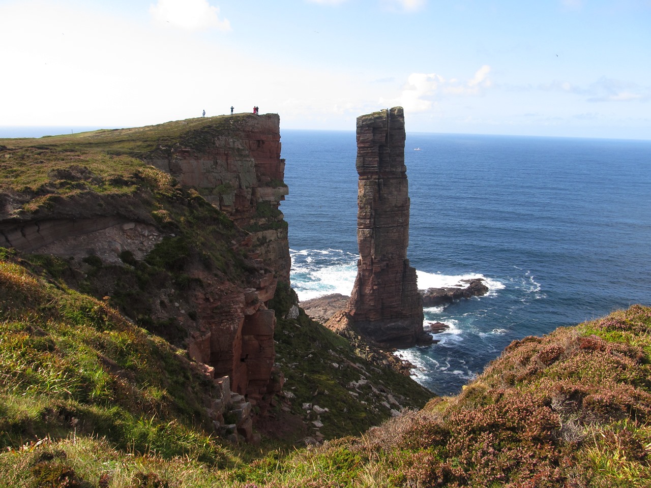
Catching the train I headed north all the way up to the city of Inverness where after a short diversion to have a look at the River Ness I went to the bus station to catch the Express coach to Orkney. I had been to Orkney just once before, way back in the year 2000, before I started to walk on every day of every holiday I got. I had been staying at the John O’Groats Youth Hostel, which used to be in the village of Canisbay a few miles away until it closed. On the day I arrived in 2000, straight after booking in, I ventured into the misty wetness of typical Caithness low cloud and walked the four miles past John O’Groats, the village famed for the being the furthest point north in Britain, to the spectacular cliff faces of Duncansby Head, the actual furthest point north-east in Britain. The rock formations were amazing despite the misty weather conditions and the fading light of the evening, and they had made the long walk along the road to get there worth it, even including the four miles to get back to the youth hostel again. Walking may not have been the primary aim of my holidays back then, but I still did a fair amount.

The next day I caught the bus to the complex of buildings beside the sea just north of the village of John O’Groats that is the spot that has been adopted by the tourists as the most northerly point, and it is from this point that day tours of Orkney set off during the summer. On that day in 2000 I took the Highlights Day Tour of Orkney, which still runs, taking the ferry across the turbulent Pentland Firth and around these magical islands. When I returned to John O’Groats I resolved to come back to Orkney and spend a longer time on the islands to really explore, but then events intervened. Firstly, while waiting for the bus back to Canisbay, I heard that Concorde had crashed, which precisely dates my visit, and then later I became more interested in climbing mountains, and for a place with no mountains Orkney held little interest for me. Thus it was that eighteen years passed before I returned to the tourist resort near John O’Groats to await the ferry across to Orkney. The coach had dropped me off with more than an hour to spare before the ferry left and I would like to say that I took advantage of the time to wander along the coast, but that would be a lie.

It was cold and windy that day so I just tried to stay warm, but when I came back from Orkney I had a similar wait for the bus so with better weather I made my way along a path that attempts to follow the shore. Erosion has forced diversions of the path but a way can still be made with the low buildings of the John O’Groats complex (and ferry terminal) behind me I headed alongside the sea around Robert’s Haven and in a very short time reached the short headland of the Ness of Duncansby. Without the time to continue along the coast to Duncansby Head I turned around and headed back to the tourist trap. A week earlier I had been standing wrapped up against the cold winds impatiently waiting for the ferry to arrive at the end of a long day of contrasts that had seen me walking through dark woodland, getting trapped in a shallow gorge, and briefly visited one of the smallest distilleries in Scotland before travelling by train and coach all the way to the famed John O’Groats. All of them faded in memory compared with the prospect of finally, after eighteen years, returning to the Orkney Islands. My return visit may have been long in waiting, but I was not to be disappointed.