Thursday 26 October 2017

The South Uist Machair

Tuesday 29th August 2017

This was the third time that I have walked across the machair of South Uist, the coastal plains that provide rich farmland for the locals and also a rich tapestry of meadows that are covered in wild flowers in the summer and are a wonderful kaleidoscope of colours entrancing the eye with every step. When I first visited the Outer Hebrides, in 2011, I walked from the Howmore Hostel as far as Daliburgh where I caught a bus back. In 2015, while making my way north along the length of the Western Isles I followed the coast up, but by the time I reached Howmore I was really tired even though this should be an easy stage of the Hebridean Way. There are no hills and the way keeps to good tracks all the way so it is a mystery why I found this walk so tough last time. On that occasion, I didn’t know the actual route of the Hebridean Way, so I had made up my own route as I went along, but as it turns out I was pretty much on the actual route. Now, two years later, I was retracing my steps all the way along the coast between the extensive beach to my right, looking out over the mighty Atlantic, and the broad machair grasslands to my left. I think the problem I had in 2015 was with my navigation despite how surprising that sounds with the sea always by my side, though that philosophy took me onto some very rough paths as I wandered around quite a bit.

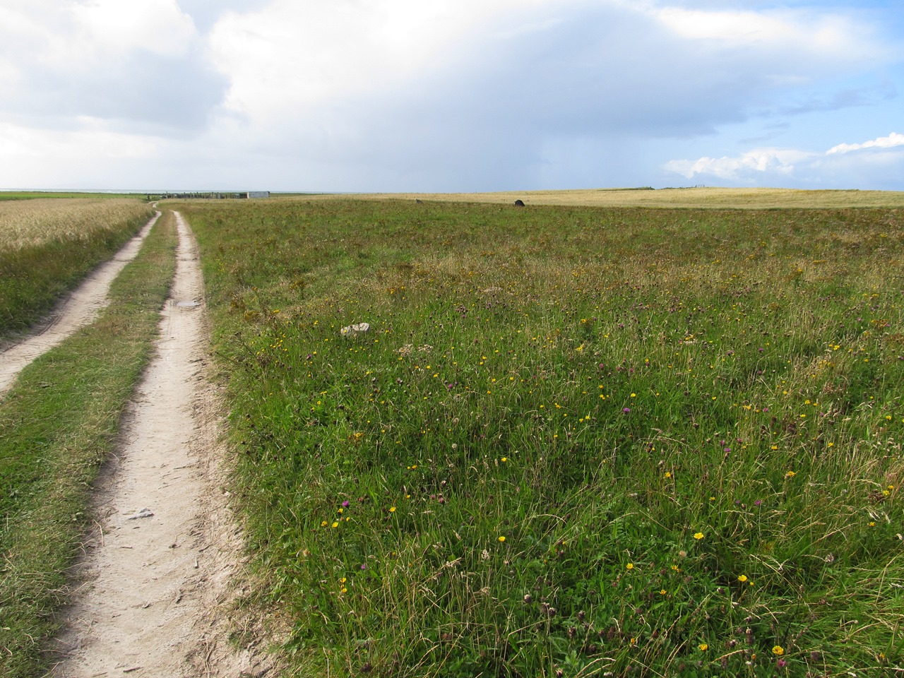
Soon after I leaving Howmore on this walk I immediately went the wrong way, going straight on to a quiet road where the Hebridean Way turns right after crossing the Abhainn Ròg. Once I’d realised my mistake I decided that from then on I would keep strictly to the Hebridean Way and not veer from it at any moment, however the signage is not great so I had to make frequent use of GPS waypoints to ensure that I kept to the route that doesn’t always keep to the coast, but often takes a route along farm tracks through the machair. The weather was quite good for this walk with long spells of sunshine that made for a pleasant day, despite the strong winds coming off the sea, with easy going tracks that enabled me to keep up a swift pace while appreciating the surrounding machair. There are few fences to interrupt the extensive views over the machair plains that are sympathetically farmed to benefit the environment with large tracts just left to go wild. After many miles I reached a signpost that directed me onto the beach that for most of the morning the Hebridean Way had been staying away from.

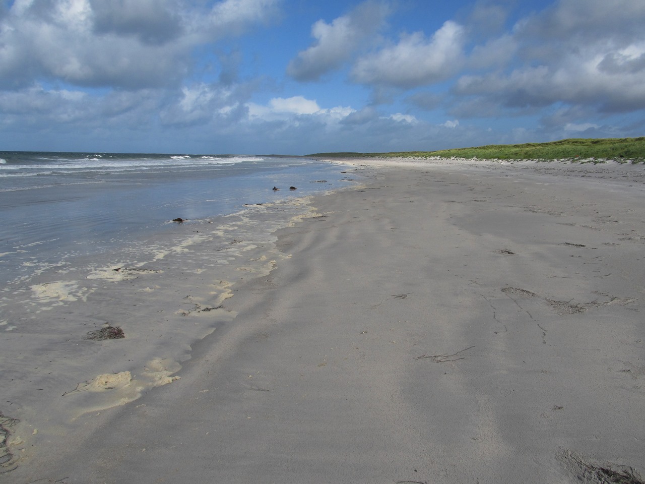
Now I took a sandy track through the dunes and onto the beach where despite the strong winds I had a wonderful stroll under blue skies over the white sands. Behind the dunes is a gold course that must rank as being one of the most spectacular, undoubtedly windiest, course anywhere in the country. It is this that had forced the Hebridean Way off the machair and onto the beach or along the edge of the dunes. After walking many miles over the machair, this was a nice change of scene, but I tired of it long before I eventually reached the marker that took me off the beach and past some ancient roundhouses. The day before, when I’d stopped at the Co-op in Creagorry, I had tried to buy enough food to take me all the way to Castlebay, but it wasn’t long before I realised that I had forgotten to buy the oatcakes that I eat with both my breakfast and my lunch. In 2015 I had diverted from the coast to the Co-op in Daliburgh, which is something that I had been trying to avoid this time, but without consciously making the decision my feet failed to keep to the trail and instead I headed towards Daliburgh. Looking at how much further I had to walk I realised that I had been making such good time I could afford to waste an hour walking all the way to Daliburgh before heading all the way back.

Returning to the point where I left the Hebridean Way I took the turning that I had earlier missed to resume my trek along the Hebridean Way swiftly making my way south through the machair battling against the strong winds until I mercifully turned the corner onto the south coast of South Uist and put the winds onto my back. Two years ago I had taken a route between the sea and the back of the Polochar Inn, but the Hebridean Way goes around the inn following the road, presumably to stop people walking past the inn as I did two years ago. In order to keep strictly to the Hebridean Way I now followed the road and headed along the coast past the camp site that I had stayed at previously (showing that I must have been walking significantly quicker than I had two years ago) and all the way along the road until I reached the Eriskay causeway. The good weather finally failed just before I reached the causeway with a short, heavy downpour that saturated me before I could get my waterproofs on. The strong winds continued on the mile long crossing of the causeway with more showers following so that by the time I reached Eriskay I just wanted to find somewhere to shelter from the wind.

Climbing over the mound to my left as soon as I reached the island I dropped down away the road onto a heavily overgrown spit of land that looks out over the Sound of Eriskay and there I threw up my tent. This walk could best be described as a march where I tried to take advantage of the smooth surface under foot to cover as many miles as I could even though the walk the previous day had already worn me out. My feet was aching at the end of that day, but they were thankfully much better when I got up in the morning; however the long walk here did nothing to help. I was once again really tired when I reached Eriskay with my legs and feet now in agony. I had gone into this holiday expecting it to be easy because I wasn’t going up any mountains, but instead I was finding it to be really tough, which surprised me. I had pushed myself on this walk, and although it had been enjoyable it had taken a heavy toll on me, so that I was relieved at the thought that the end of the Hebridean Way was now only a couple of days away.

Thursday 19 October 2017

Benbecula and South Uist

Monday 28th August 2017

After a tumultuous night beside the coast of the small Hebridean island of Benbecula with the wind howling at my tent, somehow I woke to find that my sturdy little tent was still intact even though it was still being battered about by the wind that had now moved to the west. I had positioned my tent behind Culla Bay, not far from Balivanich, where I thought it was sheltered from the winds only for those winds to move during the night and attempt to knock my tent sideward. The Hebridean Way crosses the sands of Culla Bay, but with the rain and strong winds I decided to, once I had hastily broken camp, make a course behind the shelter of the narrow strip of dunes between the beach and the machair farmland behind. At the southern end of the bay I took a quick look at the beach, but in the harsh weather it did not look appealing, however I was now back on the Hebridean Way which leaves the beach at this point to come onto the coastal road until another broad sweep of sandy beach appears. A strong smell of rotting seaweed filled the air and didn’t prompt me to follow the Hebridean Way onto the beach, but after a short spell along the top of the dunes eventually I did come down onto the sands.

It was quite enjoyable walking along the white sands of this beach despite the wind howling at me from off the sea, though it helped that the rain had mostly stopped. A thick line of foam from the whipped seas lined the edge of the tide and was being blown across the sands as I headed south. When I reached the southern end the rain had started up again so I came back off the beach, while the Hebridean Way follows the coast around the headland of Sithean Bhuirgh. I was getting quite wet from the rain being blown into my face, so I was glad to turn away from the headwind and make my way along a farmer’s track across the machair to reach the coastal road at the township of Borve. Curiously the rain seemed to stop as soon as I had come off the beach and by the time I reached the road there was a noticeable brightening of the sky. The Hebridean Way swings round the headland to follow the southern shore of Benbecula whereas I walked beside the road until I was eventually rejoined by the trail in Liniclate at the point that it comes off the beach. I never saw any sign of the Hebridean Way coming onto the road, but it should be between Liniclate School and the Dark Island Hotel.

Continuing along the road and onto the main road I stopped at the Co-op in Creagorry for supplies and when I came out I was astonished to see blue skies and sunshine. In the improving weather I made my way over the causeway to my sixth island on this trek, South Uist. When I walked the length of the Outer Hebrides two years ago, making up my own route before the Hebridean Way had been completed, I had taken a route right through the middle of M.O.D. Hebrides, a weapons Test and Evaluation Range in the north-eastern corner of South Uist. Fortunately for me it had not been active at the time, but the Hebridean Way cannot take that route so soon after reaching South Uist I now turned right away from the route that I had taken two years ago and headed along the quiet road to Ardmore. Several showers came and went at this point meaning that my waterproofs were still required until after a prolonged walk along the road where a familiar Hebridean Way signpost appeared directing me across the rain-soaked moor.

There was no trace of a path or any sign of directions for where I should be going so after wading through very wet ground I eventually made my way to a pole carrying electricity cables. From the vantage of this oasis I could see a green lane and once I reached that I had a relatively drier walk until a road came to my rescue. On this road was a sign proclaiming the Lochcarnon Community Windfarm, while in the distance three wind turbines could be seen with a wide gravel road heading off towards them. The Hebridean Way follows this stony road, but it was horrible to walk upon for my tortured feet and seemed to go on for ever while the apparently small turbines grew bigger and bigger until when I was eventually standing underneath them they were enormous and seemed very scary as the blades made ominous whooshing sounds. The weather by this point was amazing so I stopped for my lunch sitting on one of the enormous, discarded reels of electrical cabling not far from the start of a footpath that heads back across the moor.

This is an excellent, well-made path that was a joy to walk upon after the slippery stones on the road, but all too soon the path ended and I was left to make my way across the heather moor with just a line of wooden posts to mark my route. The scarcity of posts and the failure of the good path made me very depressed and fed up with the Hebridean Way that I now considered to be a boggy route, cheaply made, across waterlogged ground. I was cursing the makers of the Hebridean Way and my decision to walk upon it until finally I reached a well-made bridge across the outflow of Loch Bee where a good, gravel path resumed and took me to the main road near the large statue of Our Lady of the Isles. After a distance on this road I turned off onto the small road to Loch Sgioport that I had walked upon two years ago and on that occasion I had come across a well-made path that at the time I had wondered whether it was part of the Hebridean Way, and now I know that it is. However I was disappointed to discover a mixture of surfaces with some very good paths in places and also some very wet ground with occasional marker posts, but in the good weather it was still good to walk through the picturesque South Uist landscape with the three peaks of the island, Thacla, Beinn Choradail and Beinn Mhòr, dominating the view.

After the heavy rains of the last week all the lochs and rivers were full to overflowing and I suppose this was why the paths were very boggy, but I was not in the mood to consider this. My feet were really aching with blisters and goodness knows what else afflicting them, while I was really tired following the strong winds overnight and I had run out of water at lunchtime. And added to all that, throughout the day I had been heading into a strong wind thanks to my brilliant decision to do the Hebridean Way in the wrong direction, north to south, so I suppose it is no wonder that I was not really appreciating the trail at this point. When I reached the main road I crossed over and took a side road through Drimsdale and the machair to the west coast of the island a short distance from the youth hostel at Howmore. This was a very tiring day that had started poorly in bad weather and although the weather improved my mood did not.

Thursday 12 October 2017

Benbecula and Ruabhal

Sunday 27th August 2017

I walked most of this stage of the Hebridean Way when I was in the Outer Hebrides in 2015 despite making up my own way up the length of the Western Isles while the Hebridean Way was in the process of being constructed. On the way I found little sections of the trail that I was able to follow including the section at the start of this day. I had camped beside the muddy river that runs between the fresh water loch of Loch a’ Bharpa and the sea loch of Loch Euphort. After crossing the river on a solidly built bridge, a good path runs along the side of Bagh Orasaigh, but initially had come under attack from tall grasses that I had to wade through until the path climbed above the floodplain. I encountered a variety of surfaces on this path, starting with gravel but becoming a plastic mesh that I recalled walking on two years ago. At the time I had assumed this was a partly constructed path that would eventually be covered up with gravel, but it appears this was not the case, or maybe they just ran out of gravel. It was still dry underfoot which is all I ask for in a path, and this one took me around the western tip of Loch Euphort and onto the Sidinish road that I walked along for a spell before turning onto a track that climbed gradually uphill to continue my trek south.

After the tremendous weather that I had enjoyed the day before, on this walk conditions had now reverted to the usual Hebridean standard with grey, overcast skies and a strong breeze that was coming off the Atlantic Ocean. Despite the poor weather I had a good path to follow with some good views behind me over Loch Euphort and towards Beinn Langais, while underfoot various techniques were being used again including gravel, but also a wide turf path reminiscent of the narrower turf paths that I’d seen in Lewis. Sometimes the turf path would have the plastic mesh on top of the turf, but generally it was all dry underfoot and therefore a pleasure to walk upon despite the grey weather that was threatening rain. I enjoyed the stroll along this path looking out west towards the main road where the houses on the flat terrain looked very exposed to the winds coming off the Atlantic. After a short, steep descent that I distinctly remembered from last time the path deteriorated into a boggy track that eventually led to a gate that I also remembered from two years ago, however I knew that the Hebridean Way doesn’t join the main road at the same point where I had previously left it, opposite the Carinish Free Church.

Retracing my steps all the way back along the boggy track and up the short, steep ascent I was frustrated to discover that the Hebridean Way leaves the very good path just before the descent to head onto a pathless section heading east. There was no indication or reason why I would have expected the Hebridean Way to leave such a good path at this point and venture out across the bleak heather moor. Plain wooden posts marked the route across the moor until a faint path appeared that heads across the boggy terrain past a small collection of young deciduous trees to skirt the shores of Loch a’ Bharpa and pass a chambered cairn until I eventually reached the main road. By now it had started to rain heavily and as I made my way along the road and over the causeway I was severely whipped by the wind and rain that was making me wish I had never come to the Outer Hebrides. The tidal island of Grimsay was briefly visited before I crossed another causeway that leads to the island of Benbecula, where I finally got some shelter from the wind. The Hebridean Way is usually done in a south to north direction, but I was doing it in the opposite direction because I’d gone north two years ago.

The wind often comes from a south-westerly direction across the Western Isles, though until this point I hadn’t noticed, but now a strong head wind was blowing the rain straight into my face. When I got to the end of the causeway I turned left onto the Flodda road and during a brief respite from the wind and rain I had my lunch before turning south across the boggy moor at a Hebridean Way signpost that was pointing towards the only hill on Benbecula: Ruabhal. I very quickly lost all trace of a path in the saturated ground and while looking for the wooden posts that have usually guided me across Hebridean moorlands I saw one far to the east and headed towards it, but when I got closer I realised it was an ancient standing stone, so instead I turned towards the one marker that I could see: Ruabhal. Slowly I made my own way between two lochs and across the peaty, heather moor occasionally coming across a small wooden stake in the ground that probably marks the Hebridean Way or where the proper, larger posts should have been sited. As it is they were useless as a guide for navigation as they were far too small so I headed slowly up the hill until eventually I reached the top.

A respite from the rain had continued all the way up to the top of Ruabhal, but the views across the loch-scattered landscape were still lousy and they had been better the last time that I was on Ruabhal, even though it had not been sunny then. As the rain started to fall once again I made my way down a clear path that took me down the southern slopes of Ruabhal until I reached a track near to the point where I’d camped last time. Turning right along the track I passed the local authority recycling site and across the main road, and as the rain continued to fall, but now thankfully with a crosswind and not a headwind, I made my way west across Benbecula for several miles along a minor road until I reached the coastal road. After a short distance heading towards Balivanich I turned left to pass through the small community of Aird until I reached a small car park at the northern end of Culla Bay. Although it was still quite early in the afternoon I didn’t want to walk any further in this terrible weather, so I pitched up my tent where I hoped it would be sheltered from the winds behind the dunes. This had been another walk through hell even though the landscape and the footpaths had been good, but this time it was the weather that had ruined the day.

Thursday 5 October 2017

North Uist

Saturday 26th August 2017

After a day of rest on the lovely island of Berneray I resumed my walk along the Hebridean Way leaving the charming youth hostel as early as possible to begin my three day trek to the next hostel in South Uist. There wasn’t a breath of wind as I passed through the eerily quiet surroundings of the settlements on the eastern side of the island. At the ferry terminal I rejoined the Hebridean Way and passed over the causeway that links Berneray with North Uist, the first of many on the long chain of causeways along the length of islands that stretch all the way to Eriskay. The Hebridean Way continues along the road for another mile until just before Loch an Sticir where the now familiar Hebridean Way sign directed me onto the heather moor below the western slopes of Beinn Bhreac. Just as I’d encountered on Harris, wooden posts directed my steps across the pathless slopes to a heather topped dyke that provided me with a handrail to follow up into Bealach na Beinne, the gap that lies between the hills of Beinn Bhreac and Beinn Mhòr.

I hoped the trail was going to go through the pass as I was already tired, but much to my disappointment it continued to climb up the slopes of Beinn Mhòr and passed to the north of the summit circling around the hill to reach the eastern slopes where the stunning North Uist landscape slowly revealed itself to me. As I came round the hill the view opened out before me taking my breath away as I saw a complex terrain of land and loch where thousands of tiny islands are scattered along the complex shoreline on the eastern side of North Uist creating a landscape that is astonishing in its complexity. In the distance, the twin hills of Lì a Tuath and Lì a Deas sat at the back of the waterlogged landscape of loch and low grass-covered land. A very faint path was now beginning to appear as I dropped down the grassy slopes to reach a bridge and turned to follow the edge of the sea loch around the side of Bàgh Teileam. The ground was relatively dry and wooden boards had been provided where it was not with frequent marker posts providing a clear indication of the route even where the faint path failed.

I enjoyed this section of the walk thanks not only to the dry, clear path, but also due to the warm sunshine that was now gracing the day and providing me with the best weather of my holiday. Eventually I reached a minor road where I turned right to follow the road heading towards the twin peaks of Crògearraidh Mòr and Crògearraidh Beag until I reached the North Uist circular road. After a short distance I turned off at a sign for a car park and picnic site that took me around a brackish loch where I took the opportunity to stop and have my lunch. After eating I set off once again and soon had to follow wooden posts, but this time they were much less reliable and took me onto boggy terrain across the western slopes of Blathaisbhal. There was no hint of a path and no sign of the three standing stones marked on the map, however they are apparently no more than two feet high and are widely separated so I must have walked straight past them without realising. Eventually I came to some excavations that seem to have been made right on top of the Hebridean Way and forced me to go around the tall, metal fences that surrounded the earthworks until I reached the service road for a Scottish Water facility.

On reaching the main road I turned right to head towards Lochmaddy, the ferry terminal for North Uist. The Hebridean Way follows the road as far as Strumore, but does not go into Lochmaddy, but I wanted to see some of the town, so I took a diversion along an unfenced track to Sponish Farm where I found a rusty old suspension footpath over the outflow for Loch Houram where gorgeous views could be seen eastwards over Loch na Madadh in the fabulous weather where not a cloud was in the sky. A track led me into the delightful town of Lochmaddy overlooking the loch itself before I turned back to Strumore where I could resume my trek along the Hebridean Way using old roads that enabled me to keep away the speeding cars on the circular road. During this prolonged section clouds started to gather, but the weather brightened once more when I reached the low hill of Beinn Langais so that once again I had excellent views with the hills of Lì a Tuath, Lì a Deas and Eabhal dominating the views eastwards.

I was previously in this area two years ago while walking along the length of the Western Isles in the opposite direction and on that occasion I had climbed to the top of Beinn Langais before heading north on a route via the western side of North Uist. It was good for me to now take a completely different route through North Uist through territory that I had not walked through two years ago, though by the time I reached Ben Langais the long trudge along the old road had worn me out. On a well-made path I walked past the Langass Woodland and around the hill to eventually reach Langass Lodge where I wished that I could afford to stay, but instead I continued along the trail to reach the river that flows into Bàgh Orasaigh. Instead of staying at an expensive hotel I camped beside the boggy river where midges slowly congregated around me. Despite the tiring end to the day this was a great day with some good paths in some amazing weather that has really shown off the stunning Hebridean landscape of land and loch. Fatigue and aching feet are all worthwhile when you see landscape that is as stunning as that found in North Uist.