Thursday 25 July 2013

Ben Avon

Friday 31st May 2013

This was an amazing day that started with me waking up in a tent. I had never taken a tent with me while walking before and had actually not slept in a tent since my teens. I had excellent weather for my venture into the unknown with clear skies all night and awoke to the same excellent weather that I had gone to sleep in, except that sleep was not something that came easily. Still, it was an amazing experience to be able to just stop in the middle of nowhere, pitch up my tent and go to sleep, and it is quite appealing. My original onward route for the great trail from where I’d pitched, near the Linn of Avon overlooked by Inchrory Lodge, was to walk through Glen Builg and over Bealach Dearg to Invercauld House, but since the weather was stunning I thought I’d climb the nearby Ben Avon and bag my first Munro of the holiday. I’m sure my original route would have been a fantastic walk through valleys typical of the Cairngorms National Park, but since I had slept at the starting point of the best route up Ben Avon it was a shame to waste the opportunity.

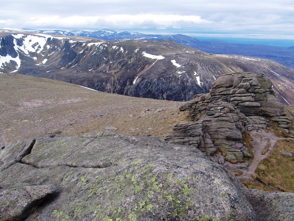
After eating my breakfast and packing up my tent I set off on a track up the heather-covered hillside. All the hills in this part of the Cairngorms seem to be heather-covered moors with little redeeming qualities, but Ben Avon is an exception. It is a vast sprawling mountain that covers a large area and I was a long way away from the summit, but between me and the top was a huge collection of rock tors that wouldn’t have been out of place on Dartmoor with some rearing up to thirty metres in height. Unfortunately I wasn’t in the right mood to appreciate them and perhaps it would have been better for me to have taken this route as a descent. I prefer to climb a mountain as quickly as possible and then linger up high as long as possible slowly descending. This climb just seemed to go on forever and after my poor night’s sleep in the tent I didn’t have the energy to run up to the top of any of the tors. I made excuses to myself that there were so many tors it wasn’t worth climbing every single one, but my rucksack was also weighing heavily on my decision to pass them all.
Nevertheless, I still had great sunshine as I passed the first rock tor, Clach Bhan, the largest of all the tors, on my right with Meall Gaineimh on my left. After passing the bristling East Meur Gorm Craig the convenient path that I’d been following faded away and I was left to make my own way across the vast grass-covered hillside. Long distances separated the tors now and I wasn't passing close enough to them to enliven the walk. I was also frustrated while trying to take pictures of them because they were sprawled so sparsely across the vast hill I found it difficult to get a good picture without getting mostly a shot of a dull grassy hillside. I guess Ben Avon isn’t a very photogenic mountain. After bypassing West Meur Gorm Craig I climbed the steep slopes of Mullach Lochan nan Gabhar to the vast summit plateau where the actual tor that is the Munro summit still lay at least a mile away across the wide hilltop past several more tors. Eventually I reached the second largest tor on Ben Avon and the summit of the mountain where I could finally rest and get some shelter from the sun.

Despite starting the climb first thing, it had taken me all morning to reach the summit of this vast mountain, so I took the opportunity to have my lunch behind the shelter of the summit tor while gradually regaining my strength. Once revived I scrambled up to the top of the summit tor and beheld the tremendous views that were all around me, particularly west towards the snow-speckled Cairngorm Mountains and the much nearer, flat-topped Beinn a’ Bhuird. This mountain is not far from Ben Avon, but lacks the rock tors that adds interest to the ascent of Ben Avon, however Beinn a’ Bhuird is the higher of the two mountains and is not only the eleventh highest mountain in Britain, but is the highest mountain in Britain that I have never visited. Despite this, when I reached the Sneck, the low point between the two mountains, I turned left and made my way south down into the valley. It wasn’t long before I met two women coming up from the valley and they couldn’t understand why I hadn’t gone up Beinn a’ Bhuird as well.

I am not interested in bagging Munros, just in having a good walk and Beinn a’ Bhuird is such a dull mountain I saw no point in climbing it. The best part of Beinn a’ Bhuird is probably the towering crags of Slochd Mòr, the great corrie north of the Sneck, and the best vantage point for that is Ben Avon. Super men, or those without a heavy rucksack, might have gone up Beinn a’ Bhuird, but I didn’t.  The two women were not even sure what mountain I’d just climbed when I told them I’d been to Ben Avon, partly because I’d pronounced it Ben A-von with the A of apple (it didn’t feel right to me to give it the same pronunciation as the Avon of Bristol), but they said it completely differently: Ben A’an. This is apparently the correct Scottish pronunciation, but why or how anyone else is supposed to know that is a mystery to me. While continuing down the hill, I had to carefully negotiate some pretty substantial snow-drifts that completely blocked my way before eventually I reached a gloriously well-made path that took me joyfully all the way down.

The sun that had continued to shine all morning didn’t last beyond lunchtime and it wasn’t long before the cloud that had quickly built up brought rain, but that didn’t bother me as I was already safely on the excellent path that took me through Gleann an t-Slugain to Invercauld House. I wasn’t impressed with Ben Avon, but it is at least better than Beinn a’ Bhuird, and I did enjoy the walk in the sun as well as the long walk out along a well-made path to Invercauld House. By the time I reached the main road I was exhausted due to the long climb, carrying an ill-fitting, heavy rucksack and due to my lack of sleep in the tent. The last thing I wanted was to have to walk more than two miles along the busy road, but that was what I had to do, and so I was very relieved when I finally reached Braemar without being hit by a car.

Thursday 18 July 2013

Loch Etchachan and Loch Avon

Thursday 30th May 2013

The night before this walk I slept in the Coire Etchachan Bothy (a bothy is a basic shelter, usually left unlocked and available for anyone to use free of charge). I wanted a little more freedom on this holiday in where I walked and where I stayed, so the first step for me was to not always stay in a youth hostel, and to try bothies. This bothy was smaller than I expected and including a group of Dutch people who camped outside, it was rather crowded. Nevertheless, I had a surprisingly restful night despite occasionally knocking feet with the person sleeping at the other end of the narrow sleeping bench, and also considering that this is the highest I’ve ever slept as the bothy is seven hundred metres above sea level. After a slow packup that had seen all the other people who were staying in the bothy leave before me, including those who had camped, I set off up the corrie just as it started to rain. After the good weather that I had seen at the end of the previous day's walk, it was disappointing for me to wake up to miserable weather again.

My original route for my great trail through the Cairngorms would have gone over the Lairig an Laoigh to the Fords of Avon, but since I was already part way up Coire Etchachan I thought I’d continue up to Loch Etchachan, where I’ve never been before. I had an enjoyable walk, despite the rain, climbing beside the Derry Burn out of the corrie and up to the side of Loch Etchachan and the awesome scenery that surrounds the loch. Ben MacDui, the second highest mountain in Britain, which forms the backdrop, was mostly covered in snow while the loch itself was almost completely frozen creating a stunning wintry scene that I rarely have a chance to see. Despite it being the end of May, winter still had a firm hold. Loch Etchachan is 927 metres above sea level and is the highest body of water of its size in the UK. While I was at the loch the rain stopped and it felt as if the whole world had paused while I gazed in awe at the stunning scenery that surrounded the loch.

I had considered climbing Ben MacDui, a mountain that I had previously visited in 2005, but the abundance of snow at the top put me off (wisely), so I eventually dragged myself away from the loch and carefully made my way across various snow-fields to the steep path that descends into the shelter stone corrie. On both my previous visits to the Cairngorm Mountains, in 2005 and in 2009, I had wanted to climb Ben MacDui from the Shelter Stone via Loch Etchachan. I was unable to on those occasions and once again on this occasion the wintry conditions prevented the ascent, but now that I have been able to experience the atmosphere of sub-arctic Loch Etchachan I’m no longer so desperate to climb Ben MacDui that way. I may not have bagged the mountain on this occasion, but I saw some stunning sights on the way and that is more important. The cliffs that surround the western end of Loch Avon are indisputably grander than those around Loch Etchachan, but I had been to Loch Avon on my previous visits and knew what an awe-inspiring sight I’d see as I dropped down to the bottom of the corrie.

Below the awesome, majestic crags that surround the end of Loch Avon is an array of rocks that have fallen off the crags and in some cases have fallen in such a way as to create convenient shelters, hence the name, the Shelter Stone. I don’t know if there is supposed to be one particular stone with this name, but I found many that could provide shelter, most of them with small stones built up at one end to keep out the elements. It does makes you wonder what it would be like to spend the night under one of these huge rocks, and whether claustrophobia would begin to set in. After creeping underneath one to experience the cave-like cavity it started raining again, but rather than sheltering under the rock I made my way down to the small river that feeds into Loch Avon. The previous day I had noticed that the rivers were full, so since I’d had difficulty crossing the Fords of Avon in 2009, I thought this diversion would be easier, but all I found was that the river on this side of Loch Avon was also a torrent.

The river was fast moving and very deep, and despite walking up and down the bank of the river many times I decided that I would just have to take the plunge, get my feet wet and rely on my walking poles to stop me from being washed away. Eventually I managed to get across with wet feet and wet legs all the way up to my knees, but I did make it safely across and started to walk beside the river and subsequently alongside Loch Avon. I never take off my shoes and socks for crossing rivers as it is much better to have the firm foothold of my boots rather than my sensitive, slippery bare feet, and besides, there were plenty of streams and bogs on the path ahead of me to ensure that if my feet didn’t get wet crossing the river, then they would definitely be wet by the end of the day. The path beside the loch was atrocious, very muddy and wet, but the sun came out! The rain stopped soon after I crossed the river and the sun came out before I had my lunch. The bog-trot continued past the end of Loch Avon all the way to the Fords of Avon.

After a short rest at the fords I set off on a long, solitary trek down Glen Avon. The path beyond the fords was better, still with some bogs but the terrain was completely different. After walking through a narrow, vee-shaped valley, the glen broadened to a landscape without the majestic crags typical of Ben MacDui and replaced by bleak, heather moors on gently sweeping hills. The path improved to a good track when I reached Faindouran Lodge, another bothy, where I considered spending the night, but since it was still quite early and the sun was shining I felt like keeping walking. Despite the uninspiring scenery at the start I really enjoyed my long stroll down this tranquil, isolated valley. A small ravine and mysterious tors at the top of the hills kept my interest as I swallowed up the miles until eventually I reached a broad grassy field just beyond the Linn of Avon that would be a perfect location to pitch a tent, and so for the first time in my walking career that was what I did, and spent the night under canvas.

Thursday 11 July 2013

Lairig Ghru

Wednesday 29th May 2013

This was a long, complex and tiring day as I got to grips with this great trail through the Cairngorms National Park that I have devised myself and passes close by all of the most significant mountains in the park. I set off from the Cairngorm Lodge Youth Hostel on the glorious Allt Mór Trail that I have taken many times before and really enjoyed every time. This well-constructed route follows the Allt Mór burn through a richly planted valley that is an absolute delight to walk through, especially in descent at the end of a long walk on the Cairngorm massif. On this occasion I was carrying a heavy rucksack upstream, so it was not the relaxing walk I was used to, but a tiring climb through a wonderfully wild valley until I reached a bridge over the burn. I had considered diverting away from my prescribed route in order to take in the top of Ben MacDui, the highest point in the Cairngorm Mountains, and the second highest point in Britain. However the low cloud, strong winds and the abundance of snow on the high tops convinced me to go around Ben MacDui over the Lairig Ghru, a highly visible pass through the Cairngorm Mountains that I was actually keen to do.

After crossing the Allt Mór I followed a heavily constructed path that I despaired over the first time I took the path, but after eight years of blending into the scenery I now considered it a very good path. I think I now appreciated it as a path that kept me out of the bog, and I have definitely seen paths that are a lot worse, mostly in the Lake District. The path goes along the northern edge of the Allt Mór after it has swung west to cross the heather moorland that lies in front of the northern corries of the Cairngorm Mountains that were looking rather murky in the dull, misty conditions. They did not look very inviting and reassured me that I had made the right choice to head through the Chalamain Gap. This narrow pass got into the news a couple of months ago when an avalanche in this relatively innocent pass claimed the lives of three experienced mountaineers. The Scottish mountains claimed the lives of a surprisingly large number of people during the last, particularly harsh, winter and shows the risks associated with walking in Scotland in wintry conditions.

The harsh winter was taking a long time to release its grip on the mountains and even at this point in the year there was still a sizeable amount of snow blocking the eastern end of the Chalamain Gap. I have always enjoyed the challenge of walking through the pass, but knowing about the recent deaths and the amount of snow at the beginning made my traverse a little worrying. With the aid of my walking poles I was able to safely cross the snow-field and then, after stowing my poles away, I crossed the boulder field in the Chalamain Gap to the boggy ground on the other side. Here the path was atrocious and I longed for the heavy construction of the other side of the pass as I struggled through the boggy ground, across the hillside and down into the valley at the foot of the Lairig Ghru. The sheer sides of the pass were intimidating and let me know that I was approaching what is probably the greatest mountain pass in the whole of Scotland. Either side of the Lairig Ghru are some of the highest mountains anywhere in Britain and the highest point on the pass itself would dwarf most of the fells in the Lake District.

After reaching the Allt Druidh I was immediately confronted by an enormous snow drift that completely covered the path and the stream. Carefully I crossed the snow-field to the other side and made my way up the valley on the stony path all the way up to the top. It was taking me so long to get to the top of this enormous pass that I started to remind myself of the indicators for reaching the top of a pass. Firstly, if the water in the stream is still heading towards you then you know you’re not there yet. You’ll know that you are at the top of the pass when you can see the view down the other side, and it took me a long time to get to that point. Eventually, after a lot of effort dragging my heavy rucksack up the hillside, I eventually reached the point where I could categorically say that I was at the top of the pass. I was so relieved, and tired, that I collapsed onto the floor and when I had recovered the energy to lift my head there was a pair of ptarmigan just a couple of metres away from me.

I had my lunch at the top before continuing for mile after mile down the other side of the Lairig Ghru past the enlarged Pools of Dee and the awe-inspiring Garbh Choire to my right. The great crags that surround this corrie were a tremendous sight, even in the poor weather. I had been over the Lairig Ghru only once before, back in 2009 when I had climbed the mountains to the west of the pass. On that occasion I had a lot more energy than now as I climbed four Munros after climbing over the pass. Now, after passing Corrour bothy, I turned left around the hillside into a bleak, dreary area of bogs and heather under dull, grey skies until eventually I descended into Glen Luibeg where wonderful trees littered the valley beyond. I got my feet wet trying to cross the swollen Luibeg Burn (I didn’t know the Luibeg Bridge was a short distance upstream), but I didn’t care as the sun came out while I walked through Glen Luibeg, past Derry Lodge and into Glen Derry. Despite the sunshine I had a strong headwind and I was really tired after my long, tiring walk carrying a heavy rucksack over the Lairig Ghru. I struggled on up the valley and eventually reached the Coire Etchachan Bothy where I spent the night. This was a long, tiring walk where snow-fields and overflowing streams through strenuous mountainous terrain made for a very difficult day.

Thursday 4 July 2013

Rothiemurchus Forest

Tuesday 28th May 2013

After realising that there was a problem with how I have done my Scottish holidays in recent years, I decided to completely rethink them. In England and Wales I had started to do more long-distance walks, but I hadn’t followed that pattern into Scotland, so now that was to change. No longer would I stay in one place and try to go up the hills in the area, even if they were a long way from my base. Ten years ago I only had one goal in my mind: that of going up mountains, but now hill-bagging holds less interest for me while ten years ago it was long-distance walks that failed to interest me. I’m always amazed at how things change over time, especially in myself. I have been subscribed to "The Great Outdoors" magazine for a couple of years now and its emphasis on backpacking has been difficult to ignore, so I decided I would now have a go myself with a long-distance walk that I have devised myself through the Cairngorms National Park.

My route doesn’t go to the top of any mountains, but it does go over some very high mountain passes, and, if I feel like it and the weather’s good, I can always detour to the tops of some of the mountains that I pass. Since I invented this trail I can change it as much as I want! The long-distance walk starts in Aviemore and leaves the town on the route seven cyclepath, crossing the River Spey and beside a road until it leaves both road and cyclepath for the quiet road (I never saw a car on it) to Blackpark and Whitewell. I was immediately impressed with this walk as I wasn’t walking on the busy road, but on an off-road cyclepath before heading through tranquil woodland and farmland on a deserted road. At Blackpark, where the road veers to the left, I continued along a bridlepath to the stunningly picturesque Loch an Eilein that has been described as the most beautiful loch in Scotland, but I’ve always had difficulty getting a good picture of it.

My journey on the train from Stirling to Aviemore had used up most of the morning, so when I reached Loch an Eilein I had my lunch, sheltering from the sun under trees beside the popular loch. The weather was fabulous, bringing out scores of people that had filled the car park and many of whom were taking the path around the loch. I have never walked around this loch before and almost wish I’d stopped to take in this walk as with the sun shining the scenery was stunning, but I had a long walk ahead of me, and my rucksack was already feeling impossibly heavy. This first day of my walk was on the same route that I’d taken in 2009, the last time I was in the Cairngorm Mountains, but in the opposite direction. On that occasion it had been my route out of the area, and now it was my route in. As I saw on that occasion the paths through the Rothiemurchus Forest between Loch an Eilein and Loch Morlich are excellent, passing through open woodland that is completely different to the dense conifer plantations that cover many parts of Scotland.

The Rothiemurchus Forest is a remnant of the great Caledonian Forest that once covered the whole of Scotland and is predominantly made up of Scots Pine as well as Aspen, Birch, Rowan and Willow, Cherry, Holly and Juniper. It is a lovely place to walk, but it is also a popular place for cyclists meaning that I had to keep to one side of the path at all times to allow enough room for cyclists to safely pass me, often at speed, but this failed to rob my pleasure of walking through such a delightful wood. On the horizon to the south, I could see the Cairngorm Mountains themselves, speckled in snow and shrouded in low cloud, and that is where my long-distance walk would take me, over the Lairig Ghru, possibly the greatest mountain pass in Scotland, which has got to be a fabulous way to start a long-distance walk. But I was already not following my pre-arranged route since I was staying at the Cairngorm Lodge Youth Hostel that night, so at the crossroads, instead of turning right towards the Lairig Ghru, I kept straight on continuing through the wood towards Loch Morlich.

I passed through a much denser plantation along a tedious, wide track before reaching Loch Morlich and, turning right, I took a much more interesting path around the loch to Glenmore and the youth hostel. When I got to the youth hostel I dumped my extraordinarily heavy rucksack and immediately felt light-headed as I staggered out of the hostel, my balance severely affected by over-compensating for the heavy rucksack. I now remembered why I had adopted my previous plan for walking in Scotland: to prevent having to walk up mountains with a heavy rucksack. In 2006 I had walked up Ben Cruachan with a heavy rucksack and I decided from then on not to do so again, although I have over-filled my rucksack on a number of other occasions, most notably in 2009 when I walked from Braemar to Glenmore. The problem this time was that I was carrying enough food in my rucksack to last me until Friday afternoon and I hadn’t yet mastered the art of selecting the lightest food. My first day had not made me eager for what was to follow as my rucksack was very uncomfortable, but I was still eager for what was to come. I’d already realised that I needed a new rucksack, unfortunately it was too late to do anything about it now and I would just have to live with what I had.

I had reached the Cairngorm Lodge Youth Hostel with an hour before checking-in time, so I set off to explore this much-loved location. I have only happy memories of staying in this area as the scenery is simply divine, so I was rather gutted that I was only going to be staying there for one night. There are some really great paths nearby that I felt compelled to visit again as soon as I got to the youth hostel. I set off first towards the gap of Ryvoan and at first I despaired as I was following a wide track through a dense conifer plantation, but eventually the track narrowed and I entered a glorious area of deciduous trees where the fantastically delicious path winds a fun route across the hillside, ducking and weaving around the trees. Wild flowers, particularly primrose and wood sorrel, were in abundance throughout the hillside until the path sadly ended, dropping steeply down to the Pass of Ryvoan and An Lochain Uaine. A lovely walk down the valley brought me back to the youth hostel. This walk showed me the world of difference between commercial conifer plantations and natural woodland. I know which one I prefer.